 Catálogo de datos del IEO
Keyword
multi-beam echosounders
184 record(s)
Type of resources
Categories
Topics
INSPIRE themes
Keywords
Contact for the resource
Provided by
Years
Formats
Status
-
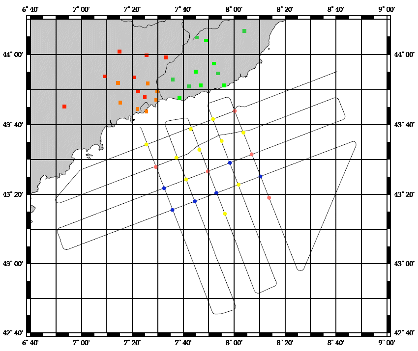
Small pelagic fish are both the keystone species of the ecosystem because of the central position they hold in the food chain and represent highly significant economic stakes for fisheries since they make up the majority of landings in the French Mediterranean (approximately 50% of catches for sardines and anchovies; Demaneche et al. 2009). So, to assess stocks and propose appropriate management methods, it is important to have both good knowledge about these species and independent fisheries data. Ifremer's fisheries science laboratory in Sète has monitored these populations since the 1990s. In 2002, the EU asked Member States to formalize certain operations by contract, in this context, the PELMED cruise was part of the extended contractual programme for biomass assessment (DCF). Therefore, each year France is obliged to assess the biomass of small pelagic species in the Mediterranean, in order to determine the stocks' status and propose management measures. These assessments are carried out in the framework of the general fisheries commission for the Mediterranean (CGPM). Since numerous countries had begun monitoring these species using acoustic methods, the MEDIAS (MEDIterannean Acoustic Surveys) scientific group was created in 2008 with the objective of standardizing the protocols. Finally, national management plans for Gulf of Lion fisheries were set up in 2014 (particularly for pelagic trawlers and purse seines) with scientific objectives touching on the biomass of small pelagics. The PELMED cruise, whose main aim is to directly assess the small pelagics biomass, is conducted therefore in a clearly institutional framework (national, European and Mediterranean). However, the scientific stakes remain just as important. Since 2008, a special situation has been observed in the Gulf of Lion, where the biomasses of sardines and anchovies (and even mackerel) have decreased synchronously. Even more unexpectedly, although the recruitment rates observed over the past few years in the species are particularly high, the populations don't seem to be growing back and their biomass is continuing to drop. This is particularly surprising in a marine ecosystem where recruitment is generally considered to be the determining factor of population dynamics for species with a short life span. The collection of biological parameters on species of small pelagics done during the previous PELMED cruises made it possible to highlight significant demographic changes (loss of large age classes, decrease in size, poorer body condition) which seem to suggest "bottom-up" population control. Therefore, the ecosystem-based nature of the PELMED cruises (from physical parameters to top predators, not to mention phyto- and zooplankton and fodder fish) appears to be crucial in understanding the dynamics of these populations. It was decided this year to stop prospecting the Catalan Sea, in order to extend the spatial coverage to the east of the Gulf in the PACA region (from Marseille to Nice). Since the narrowness of the shelf in this zone does not allow for prospecting along "classic" legs, the objective will be to validate a prospection method which is adapted to the area.
-
<p>The purpose of WestMedFlux is to study thermal fields in ocean-continent transition zones in the Western Mediterranean, and the role of fluids and salt diapirs on the thermal field.</p>
-
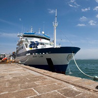
The series of PELMED cruises began in 1993. Their objective is to assess small pelagic resources in the Gulf of Lion, using the echo-integration method and trawling to identify the detections observed. Until 2007, each cruise consisted in systematically prospecting from Port-Vendres to Marseille, along 9 legs set 12 nautical miles apart, perpendicular to the coast, in daytime (6 am to 9 pm), along the entire width of the continental shelf. Acquisition along legs for acoustic prospection covered 440 nautical miles and the catches from trawling to identify the structures encountered led to a complete analysis: number and weight by species, size sampling, otolith samples taken in order to construct size-age keys for sardines, anchovies and hake, updating of biological parameters.
-
<p>Understanding the ecosystems of hydrothermal sites and their surrounding areas in the Atlantic: mapping and characterization of the geological and geochemical context, characterization of habitats, inventory of biodiversity in hydrothermal ecosystems and surrounding areas and geobiological connectivity and interaction.</p>
-

From day 6 to day 21 of the month of October the B / O Vizconde de Eza made the first of a series of multidisciplinary campaigns aimed at improving knowledge of El Cachucho fishing ground, located on the Asturian marginal shelf within the Spanish EEZ. This fishing ground is characterized by being a very irregular zone, presenting slopes greater than 45 degrees in some areas. The study of benthic communities and demersal fish was supported by exhaustive studies of other disciplines in order to obtain information about their environment and existing trophic relationships. The results obtained, and analyzed separately, of each discipline are of great value due to the unique characteristics of the fishing ground, but the common effort of the participants to relate all the subjects adds to the campaign an incalculable value in the scientific field and unique knowledge for the management of the fishery in the current framework that advocates sustainable development. GOALS Due to the scarce bathymetric information in the fishing grounds, the first part of the campaign focused on obtaining an accurate bathymetry of the study area that served as the basis for the physical, chemical, geological and biological studies that the different participating teams carried out. then. WORK AREA Image of the work area comprising the upper part of the Le Danois bank and the area between this elevation and the Lastres canyon The bank's funds are difficult to access, due to their depth and relief, for most of the instruments that come into contact. This limits the area of the study area. Mainly the works were oriented to the upper part of the bank Le Danois and to the area between this elevation and the Lastres
-
From day 12 to day 31 of the month of April the B / O Vizconde de Eza made the first of a series of multidisciplinary campaigns aimed at improving knowledge of El Cachucho fishing ground, located on the Asturian marginal shelf within the Spanish EEZ. Morpho-sedimentary study of the "El Cachucho" fishing ground and adjacent area. Dynamics and characteristics of water bodies. Characterization of benthic and demersal communities.
-
The main objective of the project ATLANTIS is the study of fishing activities and marine resources of commercial interest in the FAO statistical subareas 41.3.1 and 41.3.2, within an ecosystem approach, paying particular attention to interactions between fishing activities and Vulnerable Marine Ecosystems, mainly on the High Seas of the SW Atlantic. From 1988 the IEO scientific observers onboard programme, gives commercial, biological, oceanographic and physical data (bathymetry, surface and sea bed temperatures, etc). A series of research cruises were carried out from 2007, on board the R/V Miguel Oliver, with the main objective of said research cruises was the quantitative, qualitative and geographical study and identification of the Vulnerable Marine Ecosystems and of the vulnerable organisms in the taxonomic groups who could live in the study area, including the proposal of marine areas to be protected, to allow sustainable exploitation of fishing resources without endangering the Vulnerable Marine Ecosystems. During the research cruises undertaken, from the surface to 1,500 m, in the south western Atlantic waters between 42ºS and 48ºS, a variety of data was obtained from the fieldwork on geology, geomorphology, benthos, fisheries and physical oceanography. The results include: a detailed cartographic and bathymetric study of the area, a description of the geological substratum and of the benthic features, an analysis of the abundance and distribution of the species of largest commercial fishing interest, a footprint analysis of the fishery, an identification and a description of the Vulnerable Marine Ecosystems. The research undertaken and its main findings led to the delineating of several areas to be protected, with a total area of 41,000 km2, according to presence of organisms classified as vulnerable.
-
<p style="margin-left:0cm; margin-right:0cm">This multidisciplinary and integrated study comprises geophysical, sedimentological and (bio)geochemical data and aims to present a holistic view on the interaction of both environmental and geological drivers in cold-water coral mound development in the Gulf of Cadiz. In this context, it was fundamental to obtain "samples from the deep" to explore and characterize the biodiversity thought (1) geophysical and video imaging, (2) targeted microbiological profiling, (3) evaluation of present and past oceanic conditions.</p> <p style="margin-left:0cm; margin-right:0cm">Targeted microbiological and biogeochemical transects with long sediment cores were proposed to elicit the 3D spatial architecture and diversity of the microbial mound community and its possible role in slope stabilization. Off-mound cores were also targeted in order to evaluate present and past oceanic conditions by dating of the cored sequences and by reconstruction of water mass and sedimentary dynamics variability for eliciting the time frame of natural biodiversity changes.</p> <p style="margin-left:0cm; margin-right:0cm">The key objective aiming to investigate the microbial diversity and the functional link microbes-metazoans was addressed through biogeochemical approaches (biomarkers), molecular fingerprinting (DGGE, 16S rRNA), fluorescence in situ hybridization (FISH) and laboratory culture. This also includes the analysis of microbial infestation of coral frame builders and fauna-microbe interactions, in general, and the analysis of microbially mediated processes of carbonate precipitation, at various sites and scales: coral mucus, carbonate crusts, mound slopes, mound interior.</p> <p style="margin-left:0cm; margin-right:0cm">The sites targeting was mainly prepared by geophysical surveying (high-resolution sparker seismics, multibeam bathymetry) and ROV imagery, performed by RCMG (Ghent University). Especially the location of all on-mound core sites was determined from interpretation of the ROV Genesis dives during the CADIPOR III campaign of June 2007 on board of R/V Belgica. Additional information was made available through cooperation within past or ongoing European projects such as ESF EuroMARGINS "Moundforce", EC FP5 RTN "EURODOM" and EC FP6 IP "HERMES". Although the MiCROSYSTEMS-MD169 cruise focus was on the Pen Duick Escarpment (PDE), (8 sites, Figures 1 and 2) also other sites such as Conger Cliff (Vernadsky Ridge) and Mercator Mud Volcano were sampled. Special attention was given to the two proposed drill sites for IODP Full proposal 673 "Atlantic Mound Drilling 2: Morocco Margin". A total of five main site locations were identified:<br> 1)The Pen Duick Mounds: Alpha, Beta, Gamma and Epsilon Mounds,<br> 2) The Vernadsky Ridge mounds: Conger Cliff,<br> 3) A depression site at the foot of PDE,<br> 4) Palaeoceanographic reference sites,<br> 5) Mercator Mud Volcano.</p> <p style="margin-left:0cm; margin-right:0cm; text-align:center"><img alt="" src="https://campagnes.flotteoceanographique.fr/campagnes/8200100/images/426.png" style="height:244px; width:500px"></p> <p style="margin-left:0cm; margin-right:0cm"><em>Figure 1: Shipboard map of the SF11 multibeam bathymetry with site tracks.</em></p> <p style="margin-left:0cm; margin-right:0cm">The coring and subsampling strategies used during this campaign were predominantly site-dependent, distinguishing between "on-mound" and "off-mound" sites. Every on-mound site was cored at least two times; one core for geochemistry and microbiology, to be sampled immediately on board, and a second core for sedimentology, palaeoceanography and chronostratigraphy, to be left unopened and stored immediately.
-
Studying the role played by formation of deep water in the chemical composition and budgets of matter in the Mediterranean. Understanding the relationships between the way plankton food webs are organized and the hydrodynamic structures. The related project is MISTRALS - MerMEX.