Catálogo de datos del IEO
Campaña: MD 169 / MICROSYSTEMS
<p style="margin-left:0cm; margin-right:0cm">This multidisciplinary and integrated study comprises geophysical, sedimentological and (bio)geochemical data and aims to present a holistic view on the interaction of both environmental and geological drivers in cold-water coral mound development in the Gulf of Cadiz. In this context, it was fundamental to obtain "samples from the deep" to explore and characterize the biodiversity thought (1) geophysical and video imaging, (2) targeted microbiological profiling, (3) evaluation of present and past oceanic conditions.</p>
<p style="margin-left:0cm; margin-right:0cm">Targeted microbiological and biogeochemical transects with long sediment cores were proposed to elicit the 3D spatial architecture and diversity of the microbial mound community and its possible role in slope stabilization. Off-mound cores were also targeted in order to evaluate present and past oceanic conditions by dating of the cored sequences and by reconstruction of water mass and sedimentary dynamics variability for eliciting the time frame of natural biodiversity changes.</p>
<p style="margin-left:0cm; margin-right:0cm">The key objective aiming to investigate the microbial diversity and the functional link microbes-metazoans was addressed through biogeochemical approaches (biomarkers), molecular fingerprinting (DGGE, 16S rRNA), fluorescence in situ hybridization (FISH) and laboratory culture. This also includes the analysis of microbial infestation of coral frame builders and fauna-microbe interactions, in general, and the analysis of microbially mediated processes of carbonate precipitation, at various sites and scales: coral mucus, carbonate crusts, mound slopes, mound interior.</p>
<p style="margin-left:0cm; margin-right:0cm">The sites targeting was mainly prepared by geophysical surveying (high-resolution sparker seismics, multibeam bathymetry) and ROV imagery, performed by RCMG (Ghent University). Especially the location of all on-mound core sites was determined from interpretation of the ROV Genesis dives during the CADIPOR III campaign of June 2007 on board of R/V Belgica. Additional information was made available through cooperation within past or ongoing European projects such as ESF EuroMARGINS "Moundforce", EC FP5 RTN "EURODOM" and EC FP6 IP "HERMES". Although the MiCROSYSTEMS-MD169 cruise focus was on the Pen Duick Escarpment (PDE), (8 sites, Figures 1 and 2) also other sites such as Conger Cliff (Vernadsky Ridge) and Mercator Mud Volcano were sampled. Special attention was given to the two proposed drill sites for IODP Full proposal 673 "Atlantic Mound Drilling 2: Morocco Margin". A total of five main site locations were identified:<br>
1)The Pen Duick Mounds: Alpha, Beta, Gamma and Epsilon Mounds,<br>
2) The Vernadsky Ridge mounds: Conger Cliff,<br>
3) A depression site at the foot of PDE,<br>
4) Palaeoceanographic reference sites,<br>
5) Mercator Mud Volcano.</p>
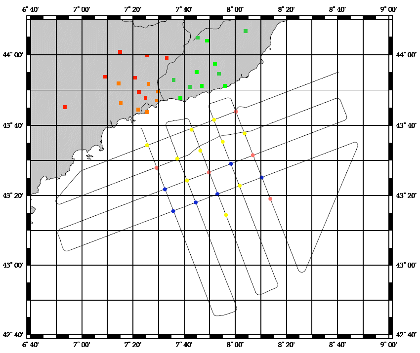
<p style="margin-left:0cm; margin-right:0cm; text-align:center"><img alt="" src="https://campagnes.flotteoceanographique.fr/campagnes/8200100/images/426.png" style="height:244px; width:500px"></p>
<p style="margin-left:0cm; margin-right:0cm"><em>Figure 1: Shipboard map of the SF11 multibeam bathymetry with site tracks.</em></p>
<p style="margin-left:0cm; margin-right:0cm">The coring and subsampling strategies used during this campaign were predominantly site-dependent, distinguishing between "on-mound" and "off-mound" sites. Every on-mound site was cored at least two times; one core for geochemistry and microbiology, to be sampled immediately on board, and a second core for sedimentology, palaeoceanography and chronostratigraphy, to be left unopened and stored immediately.
|
|
. Campaña: MD 169 / MICROSYSTEMS. http://datos.ieo.es/geonetwork/srv/api/records/urn:SDN:CSR:LOCAL:SI29200807150 |
Simple
- Título alternativo
- Referencia IEO: FI352008200100
- Fecha ( Creación )
- 2008-07-24
- Identificador
- urn:SDN:CSR:LOCAL:8200100
Orígen
Orígen
Orígen
- Estado
- Terminado
Punto de Contacto
Punto de Contacto
Punto de Contacto
- GEMET - INSPIRE themes, version 1.0 ( Tema )
-
- Oceanographic geographical features
- SeaDataNet Ports Gazetteer ( departure_place )
-
- Brest
- SeaDataNet Ports Gazetteer ( arrival_place )
-
- Algeciras
- International Standards Organisation countries ( departure_country )
-
- France
- International Standards Organisation countries ( arrival_country )
-
- Spain
- ICES Platform Codes ( platform )
-
- Marion Dufresne
- SeaVoX Platform Categories ( platform_class )
-
- research vessel
- SeaVoX salt and fresh water body gazetteer ( Lugar )
-
- North Atlantic Ocean
- SeaDataNet device categories ( instrument )
-
- thermosalinographs
- single-beam echosounders
- multi-beam echosounders
- CTD
- Limitación de uso
- Not applicable
- Restricciones de Acceso
- Restricted
- Otras limitaciones
- Idioma del metadato
- Spanish; Castilian
- Codificación
- utf8 UTF8
- Categoría temática
-
- Océanos
))
- Fecha de inicio
- 2008-07-15T00:00:00Z
- Fecha de finalización
- 2008-07-24T00:00:00Z
- Identificador del Sistema de Referencia
-
World Geodetic System 84
- Título alternativo
- L10
- Fecha ( Revisión )
- 2011-03-03
- Edición
- 3
- Identificador
- https://www.seadatanet.org/urnurl/SDN:L10
- Formato de la distribución
-
- XML (1 )
- Recurso en línea
-
Base de datos internacional con información de campañas desde 1873 hasta la actualidad. La presente campaña la podrás encontrar como MD 169 / MICROSYSTEMS.
SeaDataNet - CRS inventory
- Recurso en línea
-
Descubre si hay datos de esta campaña disponibles, utilizando para ello la etiqueta MD 169 / MICROSYSTEMS en el buscador de datos de SeaDataNet.
SeaDataNet - CDI inventory
- Jerarquía
- Campaña/Survey Campañas
Conformidad del Resultado
- Fecha ( Publicación )
- 2010-12-08
- Explicación
- See the referenced specification
- Aprobado
- true
Conformidad del Resultado
- Fecha ( Publicación )
- 2010-12-08
- Explicación
- See the referenced specification
- Aprobado
- true
- Declaración
- El Centro de datos aplica controles de calidad estandarizados a todos los datos de los que es responsable. Contacta con el Centro de datos para más información.
gmd:MD_Metadata
- Identificador del fichero
- urn:SDN:CSR:LOCAL:SI29200807150 XML
- Idioma del metadato
- Spanish; Castilian
- Codificación
- utf8 UTF8
- Jerarquía
- Campaña/Survey Campañas
- Nombre del nivel de jerarquía
- Cruise Summary record
- Fecha
- 2021-11-28
- Nombre estándar del metadato
- ISO 19115/SeaDataNet profile
- Versión estándar del metadato
- 1.0