 Catálogo de datos del IEO
Creation year
2006
182 record(s)
Type of resources
Categories
Topics
INSPIRE themes
Keywords
Contact for the resource
Provided by
Years
Formats
Status
-

CTD data in the Flemish Cap area
-
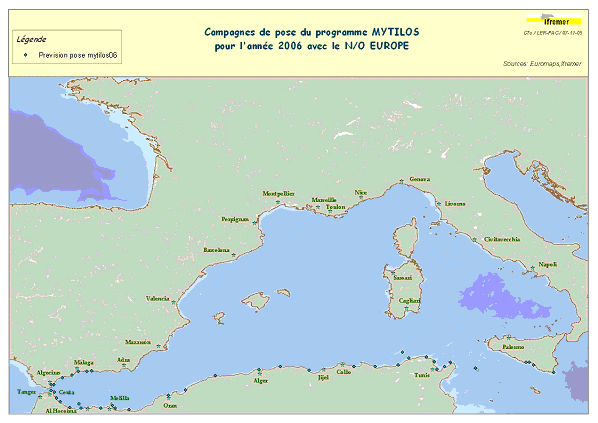
Assessment of chemical contamination in coastal water masses (Spain, Morocco, Tunisia, Sicily canal), using artificial stations of mussels. The MYTILOS1 cruise aimed to utilize the RINBIO network methodology around the western Mediterranean, in the northern part of the NW Basin. Experiments run in the French Mediterranean since 1996 by IFREMER were to be extended to Southern Mediterranean coasts, i.e. Spanish, Moroccan, Algerian and Tunisian coasts, as well as the Sicily Canal in Italy, on the basis of a standardized protocol. The data from MYTILOS2 cruise will supplement those obtained in 2004 and 2005 during the RINBIOC1 and MYTILOS1 cruises by including the coasts of North Africa, Southern Spain and the island of Pantelleria. In addition, the results will be used to complement the chemical contamination budget drawn up in the framework of the European Water Framework Directive's implementation. This falls under the 'MEDICIS' project.
-
SHOM cruise aboard the Pourquoi Pas?
-
SHOM cruise aboard the Pourquoi Pas?
-
The RRS Discovery cruise 304 was conducted from 12 May to 6 June 2005 from and to Santa Cruz (Tenerife). The cruise was completed as part of the NERC founded RAPID programme to monitor the meridional overturning circulation at 26 N. The primary purpose was to service the eastern boundary and Mid-Atlantic Ridge part of the 26 N mooring array which had previously been serviced during the RRS Charles Darwin cruises 170 and 177. 12 moorings were successfully recovered, however two of the shallow eastern boundary moorings failed to release. Intense fishing activity at these sites is likely to be the cause. 12 mooring and four bottom pressure landers were re-deployed. Data from two bottom mounted inverted echosounders was uploaded via acoustic telemetry. A total of 10 CTD casts to calibrate the mooring sensors were carried out and 3 Argo floats (from the UK Met Office) were launched. The moored sensors are CTD loggers for the most part but also bottom pressure sensors, different types of current meters and inverted echosounders are used to determine the strength and structure of the meridional overturning circulation.
-

<p>?The cruise took place from 22 November to 20 December 2006 aboard RV L'Atalante. Its objective was to study the formation of passive continental margins and a special sedimentary sequence which exists all over the Mediterranean. The result of national (IUEM Brest, Géosciences Azur, University of Lille, UPMC) and European (Universities of Lisbon and Bologna, GEOMAR and AWI) cooperation, directed by Ifremer, the cruise mobilized some twenty scientists for nearly one month. The related project is GDR Marges.</p>
-
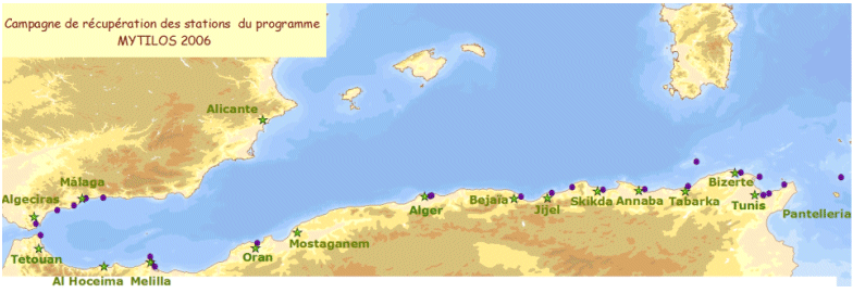
Assessment of chemical contamination in coastal water masses (Spain, Morocco, Tunisia, Sicily canal), using artificial stations of mussels. The MYTILOS1 cruise aimed to utilize the RINBIO network methodology around the western Mediterranean, in the northern part of the NW Basin. Experiments run in the French Mediterranean since 1996 by IFREMER were to be extended to Southern Mediterranean coasts, i.e. Spanish, Moroccan, Algerian and Tunisian coasts, as well as the Sicily Canal in Italy, on the basis of a standardized protocol. The data from MYTILOS2 cruise will supplement those obtained in 2004 and 2005 during the RINBIOC1 and MYTILOS1 cruises by including the coasts of North Africa, Southern Spain and the island of Pantelleria. In addition, the results will be used to complement the chemical contamination budget drawn up in the framework of the European Water Framework Directive's implementation. The survey was based on 2 major actions: 1) Artificial mussel stations were placed and recovered along a shoreline between Malaga (Spain) and Sicily (Italy), including Morocco, Algeria and Tunisia. 2) Sediment samples in addition to mussels samples were taken upon the partners' request. This falls under the MEDICIS project.
-
SHOM cruise aboard the Pourquoi Pas?
-
The major aims of Charles Darwin cruise 178 were to obtain: (i) 3D seismic imagery, video transects and swath bathymetry maps of mud volcanoes in the southern Gulf of Cadiz, (ii) video transects across suspected cold water coral reefs in the Alboran Sea, and (iii) 3D seismic imagery of submarine landslides in the Eivissa Channel, immediately east of the Balearic Islands in the western Mediterranean Sea. The cruise was in support of the EU Framework 6 'HERMES' project (Hotspot Ecosystem Research on the Margins of European Seas). A total of four 3D seismic cubes and 10 successful video transects were completed. Live chemosynthetic communities found on one mud volcano in the Gulf of Cadiz appear to indicate active methane seepage. Images of gas-charged sediments in areas of submarine landsliding in the Eivissa Channel appear to indicate a direct linkage between landsliding and fluid escape.
-
Weekly cruise to monitorize physical and chemical variables in Rias Baixas (Galicia)