 Catálogo de datos del IEO
Creation year
2020
134 record(s)
Type of resources
Categories
Topics
INSPIRE themes
Keywords
Contact for the resource
Provided by
Years
Formats
Status
Scale
-
La información contenida en este conjunto de datos es la distribución del error asociado a la de la predicción del del porcentaje de especies centinela obtenido del modelado de la proporción de especies centinela y la intensidad de la pesca de arrastre en los hábitats circalitorales y batiales sedimentarios de la demarcación Noratlántica evaluados mediante el indicador BH1-SoS (Serrano et al., 2022; Plaza-Morlote et al., 2023) en el marco del Descriptor 6 de las estrategias Marinas para el periodo 2016-2022 (Rueda et al., 2024). Se trata de una capa ráster compuesta por elementos categorizados, donde cada elemento representa el error asociado al porcentaje de especies centinela predicho por el modelo. La elaboración de este conjunto de información geográfica comenzó en 2024. La información geográfica recogida se almacena en una base de datos espaciales. Estos trabajos se han financiado gracias al Proyecto “Asesoramiento Científico Técnico para la Protección del Medio Marino: Evaluación y Seguimiento de las Estrategias Marinas, seguimiento de los espacios marinos protegidos de competencia estatal (2018-2024)”. Las Estrategias Marinas son el instrumento de planificación del medio marino creado al amparo de la Directiva 2008/56/CE (modificada mediante la Directiva UE 2017/845) por la que se establece un marco de acción comunitaria para la política del medio marino (Directiva Marco sobre la Estrategia Marina), y tienen como principal objetivo, la consecución del Buen Estado Ambiental (BEA) de nuestros mares. Los 11 descriptores del Buen Estado Ambiental constituyen la base en que se sustenta la descripción y la determinación del buen estado ambiental del medio marino. Son establecidos por la Directiva en su anexo I. Las áreas marinas de evaluación se localizan dentro de las Demarcaciones Marinas definidas en el marco de las Estrategias Marinas de España, siendo estas Demarcaciones Marinas las unidades utilizadas para la notificación a la Comisión Europea (Marine reporting units - MRU).
-
La información contenida en este conjunto de datos es la distribución del error asociado a la de la predicción del del porcentaje de especies centinela obtenido del modelado de la proporción de especies centinela y la intensidad de la pesca de arrastre en los hábitats circalitorales y batiales sedimentarios de la demarcación Noratlántica evaluados mediante el indicador BH1-SoS (Serrano et al., 2022; Plaza-Morlote et al., 2023) en el marco del Descriptor 6 de las estrategias Marinas para el periodo 2010-2015 (Rueda et al., 2024). Se trata de una capa ráster compuesta por elementos categorizados, donde cada elemento representa el error asociado al porcentaje de especies centinela predicho por el modelo. La elaboración de este conjunto de información geográfica comenzó en 2024. La información geográfica recogida se almacena en una base de datos espaciales. Estos trabajos se han financiado gracias al Proyecto “Asesoramiento Científico Técnico para la Protección del Medio Marino: Evaluación y Seguimiento de las Estrategias Marinas, seguimiento de los espacios marinos protegidos de competencia estatal (2018-2024)”. Las Estrategias Marinas son el instrumento de planificación del medio marino creado al amparo de la Directiva 2008/56/CE (modificada mediante la Directiva UE 2017/845) por la que se establece un marco de acción comunitaria para la política del medio marino (Directiva Marco sobre la Estrategia Marina), y tienen como principal objetivo, la consecución del Buen Estado Ambiental (BEA) de nuestros mares. Los 11 descriptores del Buen Estado Ambiental constituyen la base en que se sustenta la descripción y la determinación del buen estado ambiental del medio marino. Son establecidos por la Directiva en su anexo I. Las áreas marinas de evaluación se localizan dentro de las Demarcaciones Marinas definidas en el marco de las Estrategias Marinas de España, siendo estas Demarcaciones Marinas las unidades utilizadas para la notificación a la Comisión Europea (Marine reporting units - MRU).
-
La información contenida en este conjunto de datos es la distribución del grado de perturbación por la pesca de arrastre de los hábitats circalitorales y batiales sedimentarios de la demarcación Noratlántica para el periodo 2010-2015 obtenidos de la aplicación de los indicadores BH1-SoS y BH3_Ad en el marco de las Estrategias Marinas, y en concreto del Descriptor 6 de Integridad de los fondos (Rueda et al. 2024). Se trata de una capa ráster compuesta por elementos categorizados, donde cada elemento representa si el área está o no está adversamente afectada por la pesca de arrastre. La elaboración de este conjunto de información geográfica comenzó en 2024. La información geográfica recogida se almacena en una base de datos espaciales. Estos trabajos se han financiado gracias al Proyecto “Asesoramiento Científico Técnico para la Protección del Medio Marino: Evaluación y Seguimiento de las Estrategias Marinas, seguimiento de los espacios marinos protegidos de competencia estatal (2018-2024)”. Las Estrategias Marinas son el instrumento de planificación del medio marino creado al amparo de la Directiva 2008/56/CE (modificada mediante la Directiva UE 2017/845) por la que se establece un marco de acción comunitaria para la política del medio marino (Directiva Marco sobre la Estrategia Marina), y tienen como principal objetivo, la consecución del Buen Estado Ambiental (BEA) de nuestros mares. Los 11 descriptores del Buen Estado Ambiental constituyen la base en que se sustenta la descripción y la determinación del buen estado ambiental del medio marino. Son establecidos por la Directiva en su anexo I. Las áreas marinas de evaluación se localizan dentro de las Demarcaciones Marinas definidas en el marco de las Estrategias Marinas de España, siendo estas Demarcaciones Marinas las unidades utilizadas para la notificación a la Comisión Europea (Marine reporting units - MRU).
-
La información contenida en este conjunto de datos corresponde a la distribución espacial de los hábitats bentónicos del Banco de Galicia. La distribución de estos hábitats se obtuvo mediante el modelado (GAM) de datos de presencia y ausencia de dichos hábitats y se unieron todos en un sólo mapa utilizando como umbral 'kappa'. La identificación y definición de cada hábitat se realizó mediante el empleo de técnicas de análisis multivariante aplicadas sobre datos obtenidos con diversas técnicas de muestreo extractivas (arrastre y dragas). En total se realizaron 19 dragas de arrastre con puertas, 29 arrastre con ‘bou de vara’ y 27 dragas de roca. Los resultados biológicos fueron integrados con la caracterización morfosedimentaria. La zona que comprenden los datos proporcionados abarca las aguas y el lecho marino del propio Banco de Galicia (Demarcación Noratlántica) y de un conjunto de montes submarinos y zonas adyacentes. Se trata de un conjunto de datos compuesto por elementos poligonales, donde cada elemento representa un hábitat bentónico. Cada objeto tiene asociada una serie de variables alfanuméricas que se corresponden con los diferentes códigos y nomenclaturas de los diferentes hábitats en las diferentes listas o catálogos internacionales y nacionales y de hábitats bentónicos. La elaboración de este conjunto de información geográfica comenzó durante el desarrollo del plan INDEMARES, gracias a las 3 campañas oceanográficas que se realizaron entre 2009 y 2011 en el marco de dicho proyecto. La información geográfica recogida se almacenan en una base de datos espaciales. Estos trabajos se han financiado gracias al Proyecto LIFE IP INTEMARES (LIFE-IP INTEMARES - Integrated, Innovative and Participatory Management for N2000 network in the Marine Environment - LIFE15 IPE/ES/000012). Este proyecto integrado tiene el reto de sentar las bases para gestionar de forma eficaz los espacios marinos de la Red Natura 2000 y completar los trabajos y avances impulsados en el marco del proyecto LIFE+ INDEMARES, que logró dar un gran paso en materia de declaración de nuevos espacios.
-
La información contenida en este conjunto de datos son los muestreos lineales realizados con el ROV Liropus durante la campaña CIRCA-LEBA-0523 realizada en aguas del Mediterráneo español en mayo del 2023 para caracterizar las comunidades bentónicas de los fondos circalitorales y batiales rocosos en el marco de las Estrategias Marinas. Se trata de la representación de la distribución espacial de las estaciones realizadas con dicho muestreador. La zona que comprenden los datos proporcionados abarca una parte de la Demarcación Levantino-Balear (LEBA), en concreto las Islas Baleares. Se trata de un conjunto de datos compuesto por elementos lineales, donde cada elemento representa una estación de ROV. Cada objeto tiene asociada una serie de variables alfanuméricas como son posición de inicio y fin del transecto, fecha, hora, velocidad del barco y profundidad. La elaboración de este conjunto de información geográfica comenzó en 2023. La información geográfica recogida se almacena en una base de datos espaciales. Estos trabajos se han financiado gracias al Proyecto “Asesoramiento Científico Técnico para la Protección del Medio Marino: Evaluación y Seguimiento de las Estrategias Marinas, seguimiento de los espacios marinos protegidos de competencia estatal (2018-2024)”. Las Estrategias Marinas son el instrumento de planificación del medio marino creado al amparo de la Directiva 2008/56/CE (modificada mediante la Directiva UE 2017/845) por la que se establece un marco de acción comunitaria para la política del medio marino (Directiva Marco sobre la Estrategia Marina), y tienen como principal objetivo, la consecución del Buen Estado Ambiental (BEA) de nuestros mares. Los 11 descriptores del Buen Estado Ambiental constituyen la base en que se sustenta la descripción y la determinación del buen estado ambiental del medio marino. Son establecidos por la Directiva en su anexo I. Las áreas marinas de evaluación se localizan dentro de las Demarcaciones Marinas definidas en el marco de las Estrategias Marinas de España, siendo estas Demarcaciones Marinas las unidades utilizadas para la notificación a la Comisión Europea (Marine reporting units - MRU).
-
La información contenida en este conjunto de datos se corresponde con el LIC del Banco de La Concepción (ESZZ15001), una de las áreas de estudio del proyecto INTEMARES. El monte submarino denominado Banco de La Concepción está ubicado al norte de Lanzarote (Islas Canarias - Macaronesia - Océano Atlántico). Se trata de un solo elemento poligonal que representa el área de estudio y se corresponde con los límites del LIC. El objeto tiene asociado las variables alfanuméricas de área en distintas unidades y la profundidad mínima y máxima alcanzada. La información geográfica recogida se almacenan en una base de datos espaciales. En la zona se han realizado varias campañas oceanográficas. Estos trabajos se han financiado gracias al Proyecto LIFE IP INTEMARES (LIFE-IP INTEMARES - Integrated, Innovative and Participatory Management for N2000 network in the Marine Environment - LIFE15 IPE/ES/000012). Este proyecto integrado tiene el reto de sentar las bases para gestionar de forma eficaz los espacios marinos de la Red Natura 2000 y completar los trabajos y avances impulsados en el marco del proyecto LIFE+ INDEMARES, que logró dar un gran paso en materia de declaración de nuevos espacios.
-
La información contenida en este conjunto de datos se corresponde con el LIC del Banco de La Concepción (ESZZ15001), una de las áreas de estudio del proyecto INTEMARES. El monte submarino denominado Banco de La Concepción está ubicado al norte de Lanzarote (Islas Canarias - Macaronesia - Océano Atlántico). Se trata de un solo elemento poligonal que representa la zona de la campaña INTEMARES-A 4-CANARIAS-1118. El objeto tiene asociado las variables alfanuméricas de área en distintas unidades. La información geográfica recogida se almacenan en una base de datos espaciales. En la zona se han realizado varias campañas oceanográficas. Estos trabajos se han financiado gracias al Proyecto LIFE IP INTEMARES (LIFE-IP INTEMARES - Integrated, Innovative and Participatory Management for N2000 network in the Marine Environment - LIFE15 IPE/ES/000012). Este proyecto integrado tiene el reto de sentar las bases para gestionar de forma eficaz los espacios marinos de la Red Natura 2000 y completar los trabajos y avances impulsados en el marco del proyecto LIFE+ INDEMARES, que logró dar un gran paso en materia de declaración de nuevos espacios.
-
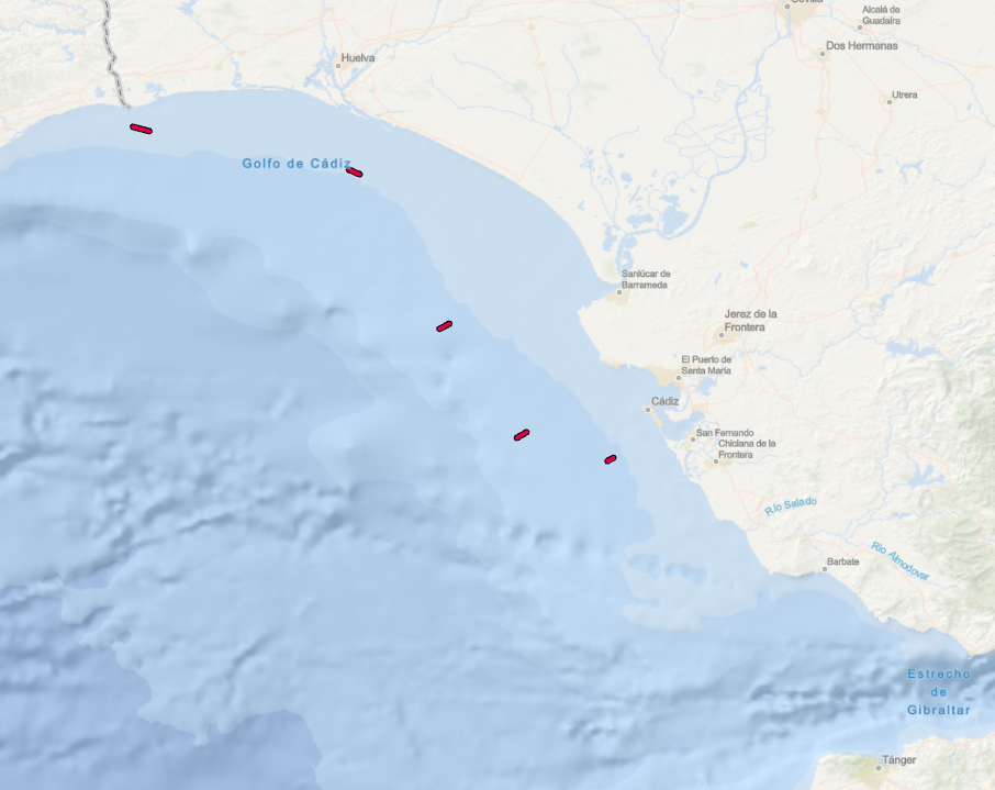
La información contenida en este conjunto de datos se refiere a la campaña PELAGO0323 llevada a cabo entre el 1 y 23 de marzo del año 2024. Se trata de la representación de los transectos de arrastre realizados con manta avani para la recogida de muestras de microplásticos en agua superficial. La zona que comprenden los datos proporcionados abarca la plataforma continental del Golfo de Cádiz (Demarcación Marina Sudatlántica). Consiste en un conjunto de datos compuesto por elementos lineales, donde cada elemento representa un transecto. Cada objeto tiene asociada una serie de variables alfanuméricas como son el nombre del transecto, el nombre de la campaña, la fecha y la georreferenciación, según el protocolo SIG del proyecto Estrategias Marinas de España (EsMarEs). La elaboración de este conjunto de información geográfica comenzó en el año 2023 gracias a la participación del grupo de basura marina del Centro Oceanográfico de Vigo (IEO-CSIC) en la campaña. La información geográfica recogida se almacena en una base de datos espaciales. Estos trabajos se han financiado gracias al Proyecto “Asesoramiento Científico Técnico para la Protección del Medio Marino: Evaluación y Seguimiento de las Estrategias Marinas, seguimiento de los espacios marinos protegidos de competencia estatal (2018-2024)”. Las Estrategias Marinas son el instrumento de planificación del medio marino creado al amparo de la Directiva 2008/56/CE (modificada mediante la Directiva UE 2017/845) por la que se establece un marco de acción comunitaria para la política del medio marino (Directiva Marco sobre la Estrategia Marina), y tienen como principal objetivo, la consecución del Buen Estado Ambiental (BEA) de nuestros mares. Los 11 descriptores del Buen Estado Ambiental constituyen la base en que se sustenta la descripción y la determinación del buen estado ambiental del medio marino. Son establecidos por la Directiva en su anexo I. Las áreas marinas de evaluación se localizan dentro de las Demarcaciones Marinas definidas en el marco de las Estrategias Marinas de España, siendo estas Demarcaciones Marinas las unidades utilizadas para la notificación a la Comisión Europea (Marine reporting units - MRU).
-
La información contenida en este conjunto de datos es la distribución de la predicción del porcentaje de especies centinela obtenido del modelado de la proporción de especies centinela y la intensidad de la pesca de arrastre en los hábitats circalitorales y batiales sedimentarios de la demarcación Noratlántica evaluados mediante el indicador BH1-SoS (Serrano et al., 2022; Plaza-Morlote et al., 2023) en el marco del Descriptor 6 de las estrategias Marinas para el periodo 2010-2015 (Rueda et al. 2024). Se trata de una capa ráster compuesta por elementos categorizados, donde cada elemento representa el porcentaje de especies centinela predicho por el modelo. La elaboración de este conjunto de información geográfica comenzó en 2024. La información geográfica recogida se almacena en una base de datos espaciales. Estos trabajos se han financiado gracias al Proyecto “Asesoramiento Científico Técnico para la Protección del Medio Marino: Evaluación y Seguimiento de las Estrategias Marinas, seguimiento de los espacios marinos protegidos de competencia estatal (2018-2024)”. Las Estrategias Marinas son el instrumento de planificación del medio marino creado al amparo de la Directiva 2008/56/CE (modificada mediante la Directiva UE 2017/845) por la que se establece un marco de acción comunitaria para la política del medio marino (Directiva Marco sobre la Estrategia Marina), y tienen como principal objetivo, la consecución del Buen Estado Ambiental (BEA) de nuestros mares. Los 11 descriptores del Buen Estado Ambiental constituyen la base en que se sustenta la descripción y la determinación del buen estado ambiental del medio marino. Son establecidos por la Directiva en su anexo I. Las áreas marinas de evaluación se localizan dentro de las Demarcaciones Marinas definidas en el marco de las Estrategias Marinas de España, siendo estas Demarcaciones Marinas las unidades utilizadas para la notificación a la Comisión Europea (Marine reporting units - MRU).
-
La información contenida en este conjunto de datos es la distribución del grado de perturbación por la pesca de arrastre de los hábitats circalitorales y batiales sedimentarios de la demarcación Noratlántica para el periodo 2016-2022 obtenidos de la aplicación de los indicadores BH1-SoS y BH3_Ad en el marco de las Estrategias Marinas, y en concreto del Descriptor 6 de Integridad de los fondos (Rueda et al. 2024). Se trata de una capa ráster compuesta por elementos categorizados, donde cada elemento representa si el área está o no está adversamente afectada por la pesca de arrastre. La elaboración de este conjunto de información geográfica comenzó en 2024. La información geográfica recogida se almacena en una base de datos espaciales. Estos trabajos se han financiado gracias al Proyecto “Asesoramiento Científico Técnico para la Protección del Medio Marino: Evaluación y Seguimiento de las Estrategias Marinas, seguimiento de los espacios marinos protegidos de competencia estatal (2018-2024)”. Las Estrategias Marinas son el instrumento de planificación del medio marino creado al amparo de la Directiva 2008/56/CE (modificada mediante la Directiva UE 2017/845) por la que se establece un marco de acción comunitaria para la política del medio marino (Directiva Marco sobre la Estrategia Marina), y tienen como principal objetivo, la consecución del Buen Estado Ambiental (BEA) de nuestros mares. Los 11 descriptores del Buen Estado Ambiental constituyen la base en que se sustenta la descripción y la determinación del buen estado ambiental del medio marino. Son establecidos por la Directiva en su anexo I. Las áreas marinas de evaluación se localizan dentro de las Demarcaciones Marinas definidas en el marco de las Estrategias Marinas de España, siendo estas Demarcaciones Marinas las unidades utilizadas para la notificación a la Comisión Europea (Marine reporting units - MRU).