 Catálogo de datos del IEO
Creation year
2008
202 record(s)
Type of resources
Categories
Topics
INSPIRE themes
Keywords
Contact for the resource
Provided by
Years
Formats
Status
-

El visor permite la visualización interactiva de los datos de biomasa de zooplancton obtenidos cada mes en las campañas RADIALES (llamadas RADCAN o RCAN desde 2013 en el caso de los tres transectos del Cantábrico: Santander, Gijón y Cudillero). Muestra un panel lateral, donde se puede seleccionar la opción deseada para una serie de variables (estación, año, tipo de representación gráfica, …) y un panel principal donde aparecen los gráficos. Está organizado en cuatro pestañas: [1] ‘Plot’ presenta los datos de una única estación (la lista de todas las estaciones y sus coordenadas geográficas están en https://seriestemporales-ieo.net, y representadas en un mapa en la última pestaña de este visor). [2] ‘multipanel’ muestra simultáneamente los gráficos individuales de todas las estaciones, facilitando la comparación entre ellas. Permite seleccionar el tipo de gráfico. [3] ‘Sampling dates’ representa gráficamente los meses, desde el inicio del proyecto, en que hay datos de biomasa de zooplancton disponibles. [4] ‘Stations Map’ muestra el mapa con la posición de todas las estaciones.
-
Timing and frequency of landslide and gravity flow geohazards along the eastern North Atlantic continental margin This research cruise was a contribution towards the NERC strategic science programme (Oceans 2025). The main scientific objective was to improve our understanding of landslide and gravity flow geohazards along the eastern North Atlantic margin, in particular by studying event timing and frequency in the recent geological record. Special attention was being paid to geohazards that may potentially impact UK communities and infrastructure. Shallow piston coring of turbidite successions in deep basins produces the best record of recent (<50 kyrs) gravity flow events on adjacent margins (e.g. Weaver et al., 2000), but the availability of pre-existing data from the study area was patchy. Consequently, a key aim of JC027 was to 'fill the gaps' and recover cores from basins, or sections of basins, where data are urgently required. A total of 60 piston and megacores was successfully recovered during the cruise, from a series of lower canyon and basin floor environments. Shallow geophysical data, including subbottom profiles and hull-mounted multibeam bathymetry, were collected quasi-continuously during the cruise to define local environment around core sites. In complex areas, such as seafloor scours, Autosub6000 was deployed to collect high-resolution EM2000 multibeam bathymetry.
-
These mooring operations were completed as a part of the United Kingdom Natural Environment Research Council (NERC) funded RAPID Programme to monitor the Atlantic Meridional Overturning Circulation at 26.5°N. The primary purpose of this cruise was to service the Eastern Boundary and Mid-Atlantic Ridge sections of the 26.5°N mooring array first deployed during RRS Discovery cruises D277 and D278 (SOC cruise report number 53), and serviced in 2005 during RRS Charles Darwin cruise CD177 (NOCS cruise report number 5), in 2006 on RRS Discovery cruise D304 (NOCS cruise report number 16) and FS Poseidon cruises P343 and P345 (NOCS cruise report number 28) and in 2007 on RRS Discovery cruise D324 (NOCS cruise report number 34). Cruise D334 started and finished in Tenerife, Spain and covered the Eastern Boundary and Mid-Atlantic Ridge moorings deployed on D324 and P343. This cruise was the fourth annual refurbishment of the Eastern Boundary and Mid-Atlantic Ridge sections of the mooring array. The array will be further refined and refurbished during subsequent years. The instruments deployed consist of a variety of current meters, bottom pressure recorders, CTD loggers and Inverted Echosounders, which, combined with time series measurements of the Florida Straits current and wind stress estimates, will be used to determine the strength and structure of the MOC at 26.5°N.
-
SHOM oceanographic cruise
-
The area in between the Audierne and St. Nazaire canyons (Gascogne) along the Armorican margin was one of the areas where the "massifs coralliens" were described for the very first time. Within the framework of the HERMES (EC FP6), MiCROSYSTEMS (ESF) and GeNeSis (FWO) projects, this area will be surveyed using multibeam and high resolution seismics during LEG 1. Based on this site survey, the ROV Genesis will be deployed to carry out detailed mapping of these deep-water "hot-spots". Also the hydrography and sediment dynamics of this area will be studied with respect to the steering of the present ecosystems. LEG 2 will focus on the Galicia bank. This location has been assigned as reference area within the ESF project BIOFUN. In addition to a bathymetric and seismic surveying, also biological sampling and experiments are planned here.
-

<p style="margin-left:0cm; margin-right:0cm">This multidisciplinary and integrated study comprises geophysical, sedimentological and (bio)geochemical data and aims to present a holistic view on the interaction of both environmental and geological drivers in cold-water coral mound development in the Gulf of Cadiz. In this context, it was fundamental to obtain "samples from the deep" to explore and characterize the biodiversity thought (1) geophysical and video imaging, (2) targeted microbiological profiling, (3) evaluation of present and past oceanic conditions.</p> <p style="margin-left:0cm; margin-right:0cm">Targeted microbiological and biogeochemical transects with long sediment cores were proposed to elicit the 3D spatial architecture and diversity of the microbial mound community and its possible role in slope stabilization. Off-mound cores were also targeted in order to evaluate present and past oceanic conditions by dating of the cored sequences and by reconstruction of water mass and sedimentary dynamics variability for eliciting the time frame of natural biodiversity changes.</p> <p style="margin-left:0cm; margin-right:0cm">The key objective aiming to investigate the microbial diversity and the functional link microbes-metazoans was addressed through biogeochemical approaches (biomarkers), molecular fingerprinting (DGGE, 16S rRNA), fluorescence in situ hybridization (FISH) and laboratory culture. This also includes the analysis of microbial infestation of coral frame builders and fauna-microbe interactions, in general, and the analysis of microbially mediated processes of carbonate precipitation, at various sites and scales: coral mucus, carbonate crusts, mound slopes, mound interior.</p> <p style="margin-left:0cm; margin-right:0cm">The sites targeting was mainly prepared by geophysical surveying (high-resolution sparker seismics, multibeam bathymetry) and ROV imagery, performed by RCMG (Ghent University). Especially the location of all on-mound core sites was determined from interpretation of the ROV Genesis dives during the CADIPOR III campaign of June 2007 on board of R/V Belgica. Additional information was made available through cooperation within past or ongoing European projects such as ESF EuroMARGINS "Moundforce", EC FP5 RTN "EURODOM" and EC FP6 IP "HERMES". Although the MiCROSYSTEMS-MD169 cruise focus was on the Pen Duick Escarpment (PDE), (8 sites, Figures 1 and 2) also other sites such as Conger Cliff (Vernadsky Ridge) and Mercator Mud Volcano were sampled. Special attention was given to the two proposed drill sites for IODP Full proposal 673 "Atlantic Mound Drilling 2: Morocco Margin". A total of five main site locations were identified:<br> 1)The Pen Duick Mounds: Alpha, Beta, Gamma and Epsilon Mounds,<br> 2) The Vernadsky Ridge mounds: Conger Cliff,<br> 3) A depression site at the foot of PDE,<br> 4) Palaeoceanographic reference sites,<br> 5) Mercator Mud Volcano.</p> <p style="margin-left:0cm; margin-right:0cm; text-align:center"><img alt="" src="https://campagnes.flotteoceanographique.fr/campagnes/8200100/images/426.png" style="height:244px; width:500px"></p> <p style="margin-left:0cm; margin-right:0cm"><em>Figure 1: Shipboard map of the SF11 multibeam bathymetry with site tracks.</em></p> <p style="margin-left:0cm; margin-right:0cm">The coring and subsampling strategies used during this campaign were predominantly site-dependent, distinguishing between "on-mound" and "off-mound" sites. Every on-mound site was cored at least two times; one core for geochemistry and microbiology, to be sampled immediately on board, and a second core for sedimentology, palaeoceanography and chronostratigraphy, to be left unopened and stored immediately.
-
Characterizing the variability of hydrological and current features and particulate fluxes on the continental rise of the Gulf of Lion and in the deep convection zone. Monitoring of deep benthic communities in the western canyons and on the continental rise of the Gulf of Lion.
-
This equipment trials cruise has provided opportunities for test and verification of technology under development at the Proudman Oceanographic Laboratory (POL), the Scottish Association for Marine Science (SAMS) and the National Oceanography Centre, Southampton (NOC,S). This includes equipment developed during the first year of funding under OCEANS 2025 (theme 8). Testing technology in the ocean environment is invaluable in assessing fitness for purpose. Specifically, the cruise tested: A Spar wave buoy (NOC,S) biogeochemical sensors (NOC,S); an UAV system (NOC,S); a video grab system "HyBis" (NOC,S), A benthic Multicore (NOC,S), A benthic lander and associated torroidal Telemetry buoy (POL), and a shallow tow towfish (POL). Testing in Spanish waters (near Tenerife, Gran Canaria and Fuerteventura) has been invaluable. The time on passage has been minimised (the transition from deep to shallow water is less than a days steaming) and the calm conditions to the southwest of the islands in the consistent prevailing north easterly winds have enabled deployment and recovery techniques to be tried and optimised in safety.
-
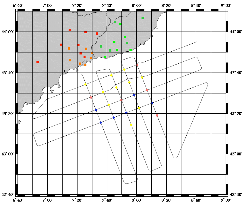
Participation in validating the CAROLS airborne L band radiometer, during flights on ATR42. CTD/LADCP stations performed on repeated sections around the Bay of Biscay and calibration of CTD tags intended for deployment on sea elephants. The related projects are CAROLS, SMOS (TOSCA/CNES and ESA), EPIGRAM (LEFE/IDAHO).
-
SHOM oceanographic cruise