Creation year
2011
203 record(s)
Type of resources
Categories
Topics
INSPIRE themes
Keywords
Contact for the resource
Provided by
Years
Formats
Status
-
The cruise is a component of RAPID-WATCH, whose objectives are: to deliver a decade-long time series of calibrated and quality-controlled measurements of the Atlantic MOC from the RAPID-WATCH array and; to exploit the data from the RAPID-WATCH array and elsewhere to determine and interpret recent changes in the Atlantic MOC, assess the risk of rapid climate change, and investigate the potential for predictions of the MOC and its impacts on climate. Objectives of this cruise: to recover, calibrate and redeploy moorings from the eastern boundary and mid-Atlantic ridge subarrays of the 26.5N line of RAPID moorings.
-

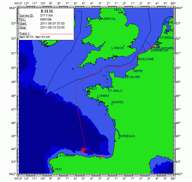
This cruise aims to investigate the seismic stratigraphy and palaeoceanographic evolution of the Le Danois contourite depositional system (Van Rooij et al., 2010), at several locations in the Le Danois "intraslope basin". Previous research (R/V Belgica in 2004, among others) has highlighted a significant correlation with the Cadiz CDS, suggesting a nearly simultaneous control by the Mediterranean Outflow Water since the Early Pliocene. As such, the Le Danois CDS is the only location in the Bay of Biscay where high-resolution climate change (e.g. bottom currents) may be recorded in a continuous way. It will assist in better constrain the role of the MOW in the thermohaline circulation system. Therefore, this large-scale sediment body is an ideal target for (a) investigating the MOW palaeoceanography within the NE Atlantic basin and (b) a palaeoclimatologic reconstruction of the Cantabrian margin. The main objective of this campaign is to acquire additional geophysical data which will give more insight in the construction and 3D evolution of this sedimentary deposit. This campaign will be executed in close cooperation with the Proyecto Coordinado CONTOURIBER (CTM 2008-06399-C04/MAR), with invited researchers from Spanish research institutes. More specifically, R/V Belgica ST1118a aims to perform: 1.High-resolution single channel sparker seismic profiling: investigation of the stratigraphic framework and the sedimentary environment in the western part of the intraslope basin between the Vizco High (west), the Lastras canyon system (east), Le Danois bank (north) and the Asturias slope (south). This will mainly focus on the lateral and temporal evolution of Le Danois drift and the Gijon drift and their interaction. The location of these profiles is determined based on industrial multichannel airgun profiles, in order to compare seismic methods with different penetration depths and seismic resolutions. We are very grateful to TGS-NOPEC for allowing us to use a large unpublished data set of seismic records from the Cantabrian Sea. 2.Hydrography: at specific sites in the intraslope basin, CTD casts will aim to better map the presence and behavior of the Mediterranean Outflow Water within the main elements of the Gijon and Le Danois drifts. The newly acquired Seapoint turbidity sensor will be able to indicate regions of active sediment transport within the Le Danois CDS. Multibeam bathymetry with the Belgica EM1002 will be only be used as a backup in case of spare time or failure of the other methods. The proponents are aware of the Marine Protected Area status of the Le Danois Bank, and will be vigilant to respect the guidelines of conducting scientific research. In order to ensure vigilance with respect to marine mammals, a team of whale watchers of MUMM, ULg (Belgium), CRMM (France) and OCEAMM (France) will be participating. This part of the campaign is a cooperation between the RCMG (UGent), the University of Vigo, the Geological Survey of Spain (IGME), the Spanish Oceanographic Institute (IEO), the Spanish Institute of Marine Sciences (CMIMA-CSIC) and the University of Cádiz.
-

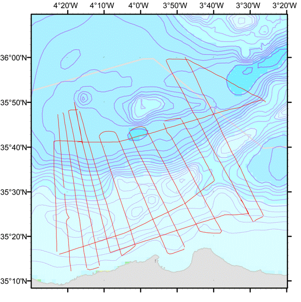
<p>The MARLBORO cruise project aimed to study Post-Messinian tectonic evolution in the South Alboran basin (Morocco). The presence of sediment formations, especially contourites (sediments deposited or reworked by marine bottom currents) and instabilities, deposited since the end of the Messinian (approx. 5.33 Ma), provide us with top rate sedimentary markers to recreate the tectonic evolution well. Moreover, the region is affected by strong quakes and by slope instabilities which cause concern. Although active accidents have been identified and recently mapped on the Andalusia margin, no such detailed studies have been conducted yet on the Moroccan margin. The Xauen/Tofino and Alboran ridges off Morocco, in the south of the Alboran Sea, were chosen for the study zone since they show both past and current signs of strong tectonic deformation, underwater landslides and activity of bottom currents whose contourite type deposits can provide an excellent stratigraphic marker. The cruise's objective was the imaging of post-Messinian structures using medium resolution reflection seismics. The cruise (7 days in the zone) made it possible to acquire about 1,100 km of reflection seismic surveys along the 15 profiles perpendicular to the ridges, and 3 profiles parallel to the ridges, in order to monitor the lateral and longitudinal evolution of contourites and of Mass Transport Deposits (MTDs), as well as the geometric relationships existing between these objects and active tectonic structures. The MARLBORO cruise is related to the French TerMex (Mediterranean margin) and Actions Marges (Améditer) programmes as well as to Spanish national Contouriber and SAGAS programmes and the international Topomed programme.</p>
-

Weekly cruise to monitorize physical and chemical variables in Rias Baixas (Galicia)
-

Weekly cruise to monitorize physical and chemical variables in Rías Altas (Galicia)
-

Weekly cruise to monitorize physical and chemical variables in Rias Baixas (Galicia)
-

Weekly cruise to monitorize physical and chemical variables in Rias Baixas (Galicia)
-

Weekly cruise to monitorize physical and chemical variables in Rías Altas (Galicia)
-

Weekly cruise to monitorize physical and chemical variables in Rias Baixas (Galicia)
-

Weekly cruise to monitorize physical and chemical variables in Rias Baixas (Galicia)
 Catálogo de datos del IEO