Creation year

2013

229 record(s)


Type of resources

Categories

Available actions

Topics

INSPIRE themes

Keywords

Contact for the resource

Provided by

Years

Formats

Status

From 1 - 10 / 229
  • Categories    

    Configuración regional operacional del modelo ROMS (Regional Ocean Modeling System) del noroeste de la Península Ibérica. En esta configuración, dos mallas se anidan durante el tiempo de ejecución. Los datos de la malla de menor resolución (4 km de resolución horizontal) 236 x 181 grid fuerzan las fronteras laterales de la malla de mayor resolución (~1.3 km) 312 x 167 que está embebida. La salidas son tanto datos instantáneos horarios como promedios diarios.

  • Categories  

    La estimación del flujo de CO2 en la superficie marina es altamente dependiente de la velocidad del viento a través de la parametrización de velocidad de transferencia gaseosa. Esta herramienta permite visualizar esta estimación usando datos obtenidos en un buque de oportunidad que transportaba vehículos de Citröen desde Vigo (España) a Saint Nazaire (Francia), desde octubre de 2002 a Julio de 2003. Puedes explorar la variabilidad especial y temporal del flujo de CO2 a lo largo de la ruta. Además, esta herramienta te permite visualizar las diferencias obtenidas en la estimación cuando se emplea un dato de viento procedente de otra fuente o bien se escoge otro algoritmo diferente para realizar la estimación. Si te gusta esta aplicación o quieres saber más, por favor, visita nuestro artículo publicado en Biogeosciences: Otero, P., X. A. Padin, M. Ruiz-Villarreal, L. M. García-García, A. F. Ríos and F. F. Pérez. Net sea–air CO2 flux uncertainties in the Bay of Biscay based on the choice of wind speed products and gas transfer parameterizations. Biogeosciences, 10, 2993-3005, 2013.

  • Categories  

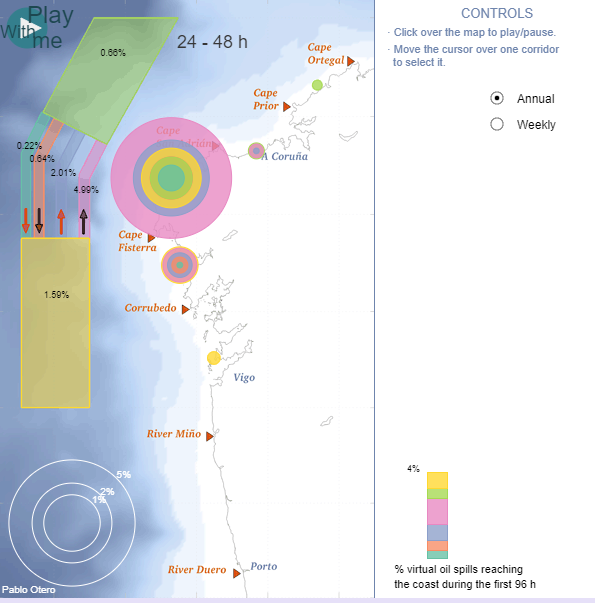
    Esta herramienta visualiza la exposición costera de la Eurorregión Galicia - Norte de Portugal a los potenciales vertidos de hidrocarburos que pudieran venir del dispositivo de separación de tráfico de Fisterra. Estos corredores son atravesados cada año por cerca de 40,000 buques; más del 30% de ellos transporta sustancias peligrosas. Estos resultados corresponden a 2012, obtenidos mediante la ejecución de 8,686 simulaciones lagrangianas, cada una de las cuales contó con 2,345 partículas virtuales que fueron arrojadas sobre el corredor y seguidas durante las siguientes 96 horas. Las partículas fueron desplazadas por corrientes superficiales marinas obtenidas de un modelo oceánico realista de alta resolución y también por la acción del viento. Se muestran además de los cuatro corredores que integran el dispositivo, las zonas de aproximación. El número que aparece sobre cada corredor es la probabilidad de que una partícula alcance la costa durante el primer, segundo, tercer o cuarto día tras el vertido. Los círculos representan la probabilidad de que alcance un determinado segmento de la costa. Es posible filtrar los datos colocando el puntero del ratón sobre un determinado corredor, facilitando la visualización.

  • Categories  

    Transit.

  • Categories  

    Studying the Messinian Salinity Crisis on the Balearic promontory and using its markers to assess post-crisis vertical movement and the reactivation of the region. 1) Fine-scale continuous mapping of evaporites from land to the deep basin in order to answer the following question: What is the spatial-temporal variability of evaporites of the Balearic Promontory (evaporites on land, very thin or thick evaporates at sea)? 2) Using the Messinian as a marker of syn- and post-MSC deformations; isolating recent movements from previous deformations and quantifying them in order to reproduce the paleo-bathymetry and paleo-connections during the crisis. Were the evaporites in shallow basins continuous with evaporites in deeper basins before the recent deformations? The related project is 'Action Marges', Mediterranean study site.

  • Categories  

    Transit.

  • Categories  

    The sediments of the Galician Interior Basin realm are capable of recording the peculiar conditions of the last glacial‐interglacial dynamics transition into the current interglacial and their evolution into present day, as they are influenced by the Thermohaline Circulation (THC) and because their proximity to the important continental land‐mass of western Iberia. The knowledge of the rates and magnitudes of change of this system is critical to understand its climate dynamics, processes and feedbacks, and hence its role on a local to sub‐regional scale. The inference of these climatic mechanisms encrypted in the deep‐sea sedimentary record needs to constrain the spatial and temporal scales of the sedimentary processes involved, in particular the identification of source areas, pathways and transport, storage times and hydrodynamic conditions. To adequately assess these encrypted sedimentary archives it is instrumental to identify the sedimentary expression of the main processes and forcements involved and accurately determine the spatial and temporal scales, rates and magnitudes of the processes and feedbacks that generate these records. This proposal aims to carry out a high‐resolution reconstruction of the transport time,provenance, sediment fluxes, wave climate, bottom‐current variability and post‐depositional alteration in a number of surficial samples and cores from the Galician Interior Basin. This project will provide a first insight into the relation between the last North Atlantic climate oscillation and the local regional components including abrupt climate changes (i.e. H events) and local events since the end of the last glacial period from a paleoclimatic proxies perspective. We will use a twofold approach by first constraining the current sedimentary conditions to their associated local wave climate and North Atlantic regional forcements to subsequently infer the paleoenvironmental conditions from the past 30‐50 ky sedimentary record. Firstly, analysing and modelling the present hydraulic conditions from newly acquired and historical wave climate and oceanographic records from the study area will study the current sedimentary conditions and forcements. These data will be linked to the present day sedimentation conditions by direct measurements of present day sedimentation and oceanographic conditions, supported by moored sediment traps, CTD, Doppler records and surficial samples. Epifauna, infauna, microfauna and sediment microestructure will also be studied. Subsequently we will udertake a multidisciplinary study combining high‐resolution geochemical, physical properties, environmental magnetic sediment derived records with high precision U‐series isotopes analyses in a well‐constrained geochronological framework. Further support will be provided by seismic‐acoustic data acquisition. The combination of these sedimentological, micropaleontological, geochemical and geophysical tools will help in better resolving the role of current strength, circulation and sediment provenance changes also considering across vs. along margin transport balances in the sedimentary record of the Galician Internal basin over the last 30‐50 ky

  • Categories  

    To estimate stratified abundances indices by age of hake, megrims and monkfishes. To estimate stratified abundances indices of commercial fish species (N. norvergicus, P. blennoides, H. dactylopterus, G. cynoglossus and rays). To estimate recruitment indices and spatial trends of younger ages of hake, megrims and monkfishes. To describe the spatial distribution patterns of demersal and benthic species of Porcupine. To collect data for the determination of biological parameters for the demersal species selected by DCF (Data Collection Framework).

  • Categories  

    Weekly cruise to monitorize physical and chemical variables in Rías Altas (Galicia)

  • Categories  

    Monthly survey to study thermohaline and biological characterization of water masses in the East-North Atlantic.