 Catálogo de datos del IEO
Creation year
2017
228 record(s)
Type of resources
Categories
Topics
INSPIRE themes
Keywords
Contact for the resource
Provided by
Years
Formats
Status
-
Small pelagic fish are both the keystone species of the ecosystem because of the central position they hold in the food chain and represent highly significant economic stakes for fisheries since they make up the majority of landings in the French Mediterranean (approximately 50% of catches for sardines and anchovies; Demaneche et al. 2009). So, to assess stocks and propose appropriate management methods, it is important to have both good knowledge about these species and independent fisheries data. Ifremer's fisheries science laboratory in Sète has monitored these populations since the 1990s. In 2002, the EU asked Member States to formalize certain operations by contract, in this context, the PELMED cruise was part of the extended contractual programme for biomass assessment (DCF). Therefore, each year France is obliged to assess the biomass of small pelagic species in the Mediterranean, in order to determine the stocks' status and propose management measures. These assessments are carried out in the framework of the general fisheries commission for the Mediterranean (CGPM). Since numerous countries had begun monitoring these species using acoustic methods, the MEDIAS (MEDIterannean Acoustic Surveys) scientific group was created in 2008 with the objective of standardizing the protocols. Finally, national management plans for Gulf of Lion fisheries were set up in 2014 (particularly for pelagic trawlers and purse seines) with scientific objectives touching on the biomass of small pelagics. The PELMED cruise, whose main aim is to directly assess the small pelagics biomass, is conducted therefore in a clearly institutional framework (national, European and Mediterranean). However, the scientific stakes remain just as important. Since 2008, a special situation has been observed in the Gulf of Lion, where the biomasses of sardines and anchovies (and even mackerel) have decreased synchronously. Even more unexpectedly, although the recruitment rates observed over the past few years in the species are particularly high, the populations don't seem to be growing back and their biomass is continuing to drop. This is particularly surprising in a marine ecosystem where recruitment is generally considered to be the determining factor of population dynamics for species with a short life span. The collection of biological parameters on species of small pelagics done during the previous PELMED cruises made it possible to highlight significant demographic changes (loss of large age classes, decrease in size, poorer body condition) which seem to suggest "bottom-up" population control. Therefore, the ecosystem-based nature of the PELMED cruises (from physical parameters to top predators, not to mention phyto- and zooplankton and fodder fish) appears to be crucial in understanding the dynamics of these populations. It was decided this year to stop prospecting the Catalan Sea, in order to extend the spatial coverage to the east of the Gulf in the PACA region (from Marseille to Nice). Since the narrowness of the shelf in this zone does not allow for prospecting along "classic" legs, the objective will be to validate a prospection method which is adapted to the area.
-
<p>The Protevs Med 2017 campaign aimed to explore the area of the northern Balearic front and the southern edge of the convection area of the north western basin at the end of winter when convection events are most likely. Sampling to target small mesoscale structures detectable by altimetry but also even smaller structures that did not sign on altimetry.</p> <p>A particular focus was placed on an anticyclonic structure in the southern Balearic Islands that is systematically detectable by altimetry but which appears to be an artifact.</p> <p>Finally, the edge of the Catalan shelf was explored at high resolution.</p> <p> </p>
-
<p>MOOSE-GE aims at 1) ensuring the maintenance of offshore French Mediterranean moorings and 2) carrying out an annual mapping of hydrological, biogeochemical and biological characteristics of the whole north-western basin. The related project are MERMEX, HYMEX, MISTRALS and MOOSE.</p>
-
<p>The Protevs Med 2017 campaign aimed to explore the area of the northern Balearic front and the southern edge of the convection area of the north western basin at the end of winter when convection events are most likely. Sampling to target small mesoscale structures detectable by altimetry but also even smaller structures that did not sign on altimetry.</p> <p>A particular focus was placed on an anticyclonic structure in the southern Balearic Islands that is systematically detectable by altimetry but which appears to be an artifact.</p> <p>Finally, the edge of the Catalan shelf was explored at high resolution.</p>
-
Weekly cruise to monitorize physical and chemical variables in Rias Baixas (Galicia)
-
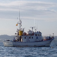
Weekly cruise to monitorize physical and chemical variables in Rías Altas (Galicia)
-
Weekly cruise to monitorize physical and chemical variables in Rías Altas (Galicia)
-
Weekly cruise to monitorize physical and chemical variables in Rias Baixas (Galicia)
-
Weekly cruise to monitorize physical and chemical variables in Rías Altas (Galicia)
-
Weekly cruise to monitorize physical and chemical variables in Rias Baixas (Galicia)