 Catálogo de datos del IEO
Creation year
2010
205 record(s)
Type of resources
Categories
Topics
INSPIRE themes
Keywords
Contact for the resource
Provided by
Years
Formats
Status
-
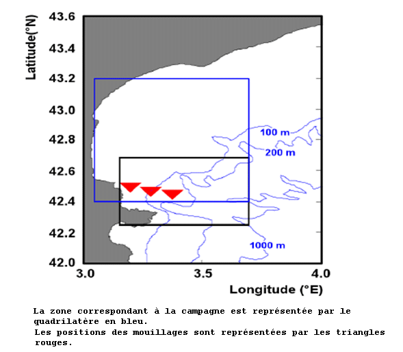
<p>Studying eddies related to water circulation in the Gulf of Lion. The LOPB and LOMIC labs will implement a technique never used before for coastal systems, i.e. tracking of a water mass using the chemically inert compound sulphur hexafluoride (SF6). After injecting the tracer from aboard RV Suroît, the substance's dissemination will be estimated thanks to real-time measurements performed on board. To monitor the eddy structure, RV Suroît will be accompanied by RV Tethys II. Several innovative devices or systems will be deployed simultaneously (measuring currents using Doppler acoustic profiler (with the moorings already in the zone since 2009 and the 2 vessels' shipboard current meters); Measuring surface currents using an array of HF radars installed onshore; several satellite-monitored drifting buoys, including a CARIOCA buoy which will continuously log the physical parameters and CO2 trends near the surface; autonomous underwater gliders fitted with various biogeochemical sensors; real-time satellite observation of surface temperature and phytoplankton concentrations; and operational numerical modelling. The measurements will be analyzed on board and will be used to locate the eddy's position in order to guide the vessels to the drifting research zone. The original aspect of LATEX is that it combines expertise in physical oceanography and marine biogeochemistry to try and penetrate the mystery of these mesoscale structures and particularly to assess the role they play in transfer of matter between the coastal zone and the open sea. The fate of organic matter will be closely observed during this monitoring of the drifting eddy structure to understand how the biogeochemical properties (quality of organic matter, stoichiometry of particulate matter, primary and bacterial production) evolve over time in this volume of water enclosed by physical processes.</p>
-
SHOM cruise .
-
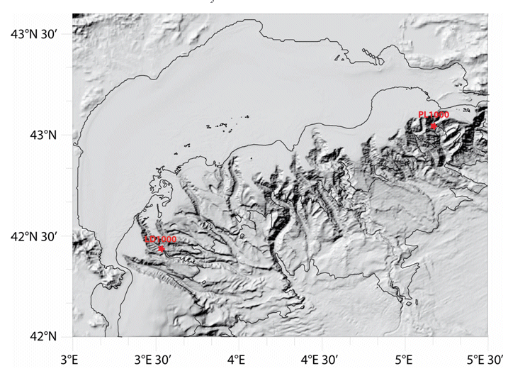
Characterizing the variability of hydrological and current measurement features and particulate fluxes in two canyons of Le Planier (station PL1000) and Lacaze-Duthiers (station LD1000) located at the easternmost and westernmost tips of the Gulf of Lion.
-
This was the fourth and last cruise undertaken as part of the NERC-funded consortium project (NE/C512961/1) entitled ECOMAR - Ecosystem of the Mid-Atlantic Ridge at the Sub-Polar Front and Charlie Gibbs Fracture Zone. http://www.oceanlab.abdn.ac.uk/ecomar/index.php ECOMAR forms part of the Census of Marine Life MAR-ECO project which is an international study of life in the northern mid-Atlantic Ocean with scientists from 16 nations participating in research of the waters around the mid-Atlantic Ridge from Iceland to the Azores (http://www.mar-eco.no). Depart: Wednesday, 26 May, St Johns, Newfoundland, Canada. Long term moorings were recovered at four super stations at a bottom depth of 2500m equipped with sediment traps, current meters, ADCP and sensor suites, SE - 49°01.92'N, 27°40.82'W, SW - 48°46.80'N, 28°38.43'W, NW - 53°59.33'N, 36°07.39'W and NE 54°00.05'N 34°10.58'W. Video and still images of the sea floor were obtained during 4 lander deployments and 21 ISIS ROV dives. Faunas samples were taken on 17 of these ROV dives, further samples from 13 successful megacorer casts and 4 baited traps. High definition video sea floor surveys were completed of approximately 50,000 m2 of sea floor. Arrive: Vigo, Spain, Saturday 3 July 2010.
-
SHOM cruise
-
SHOM cruise
-
Retrieving an array of moored current meters recording subtidal circulation on the ocean margins of the Bay of Biscay (Armorican and Aquitaine shelves and slopes). Related hydrological measurements taken. This falls under the ASPEX project.
-
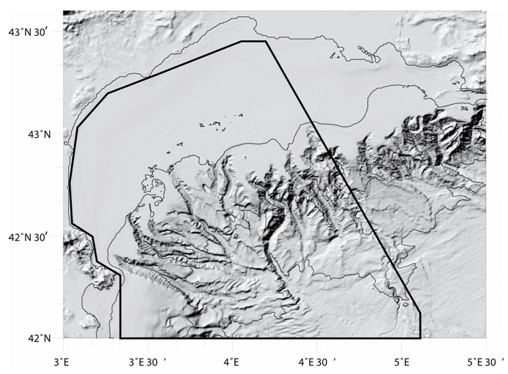
Characterizing the variability of hydrological and current features and particulate fluxes on the continental rise of the Gulf of Lion and in the deep convection zone. Monitoring of deep benthic communities in the western canyons and on the continental rise of the Gulf of Lion.
-
Understanding the role played by the combined physical-biogeochemical dynamics at (sub)-mesoscales in exchanges of matter and energy between coastal and open sea areas. The LATEX strategy is based on selective and combined use of numerical modelling and in situ observations (Lagrangian floats, SF6, shipboard ADCPs, ADCP moorings, satellite images, gliders and coastal radars). The main objective of LATEX is to study the impact of an eddy structure at (sub)mesoscale, which is chronically present in the western part of the Gulf of Lion, in interaction with the North Mediterranean current(NMC)on trends in the distribution of conservative tracers and biogeochemical properties. Thanks to this strategy, LATEX should provide answers to the following questions: - Is this type of structure likely to significantly affect the horizontal transfer of matter between the continental shelf and the NMC? - What are the consequences for biogeochemical cycles of the structure's interaction with the NMC? - How do CO2 concentrations evolve within the eddy throughout its life cycle? - How does this type of (sub)-mesoscale coastal eddy act in structuring of plankton communities and the variability in primary production observed in the study zone? - Are the amounts of matter transferred by (sub)-mesoscale structures significant with respect to that displaced by the general circulation on seasonal and annual scales? The related project is called LATEX (LAgrangian Transport Experiment).
-
Weekly cruise to monitorize physical and chemical variables in Rías Altas (Galicia)