 Catálogo de datos del IEO
Creation year
2021
229 record(s)
Type of resources
Categories
Available actions
Topics
INSPIRE themes
Keywords
Contact for the resource
Provided by
Years
Formats
Status
Scale
-
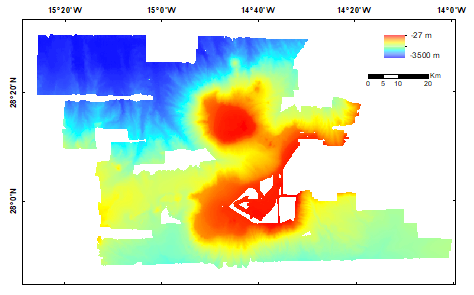
La información contenida en este conjunto de datos es un ráster de la batimetría de la zona, con una resolución de 200 m, con profundidades comprendidas entre 27 y 3500 m. La zona que comprende los datos proporcionados corresponde a los bancos de Amanay y El Banquete y sus alrededores, situados en el margen sur de Fuerteventura, perteneciente al archipiélago de las Islas Canarias e incluidos en el LIC ESZZ15002 Espacio marino oriente y sur de Lanzarote-Fuerteventura. Los datos brutos que constituyen este ráster se adquirieron durante las campañas llevadas a cabo en el proyecto INDEMARES: INFUECO_0611, INFUECO_1112 e INFUECO_1113. Durante el proyecto INTEMARES se ha realizado el reprocesado de los datos batimétricos y de reflectividad disponibles, con el fin de ampliar el estudio geomorfológico de la zona. La información geográfica recogida se almacena en una base de datos espaciales. Los trabajos de reprocesado se han financiado gracias al Proyecto LIFE IP INTEMARES (LIFE-IP INTEMARES - Integrated, Innovative and Participatory Management for N2000 network in the Marine Environment - LIFE15 IPE/ES/000012). Este proyecto integrado tiene el reto de sentar las bases para gestionar de forma eficaz los espacios marinos de la Red Natura 2000 y completar los trabajos y avances impulsados en el marco del proyecto LIFE+ INDEMARES, que logró dar un gran paso en materia de declaración de nuevos espacios.
-
La información contenida en este conjunto de datos es un ráster con la curvatura total de la zona de estudio, a 200 m de resolución. La curvatura se define como la segunda derivada de la superficie, o la "pendiente de la pendiente". Una curvatura positiva indica que la superficie es convexa hacia arriba en esa celda. Una curvatura negativa indica que la superficie es cóncava hacia arriba en esa celda. Un valor de 0 indica que la superficie es plana. La zona que comprenden los datos proporcionados abarca el LIC del Banco de Galicia. Este conjunto de información se estructura en base a la batimetría original. La elaboración de este conjunto de información geográfica comenzó en 2010 y 2011, gracias las campañas oceanográficas BANGAL 0710 y BANGAL 0711. En 2019 se acometió un reanálisis de dichos datos con nuevas técnicas y algoritmos, mejorando la calidad e interpretación de los datos. La información geográfica recogida se almacenan en una base de datos espaciales. Estos trabajos se han financiado gracias al Proyecto LIFE IP INTEMARES (LIFE-IP INTEMARES - Integrated, Innovative and Participatory Management for N2000 network in the Marine Environment - LIFE15 IPE/ES/000012). Este proyecto integrado tiene el reto de sentar las bases para gestionar de forma eficaz los espacios marinos de la Red Natura 2000 y completar los trabajos y avances impulsados en el marco del proyecto LIFE+ INDEMARES, que logró dar un gran paso en materia de declaración de nuevos espacios.
-
La información contenida en este archivo corresponde al área prospectada con ecosonda multihaz (EM710) durante la campaña CIRCAN2020, en las aguas de la demarcación canaria. Se trata de la representación del área donde se han obtenido datos tanto de batimetría como de reflectividad. La zona que comprenden los datos proporcionados abarca aguas adyacentes a las islas de Gran Canaria, Fuerteventura y Lanzarote. Se trata de un conjunto de datos compuesto por elementos poligonales, donde cada elemento representa el área prospectada con EM710 con cobertura 100%. La información geográfica recogida se almacena en una base de datos espaciales. Estos trabajos se han financiado gracias al Proyecto “Asesoramiento Científico Técnico para la Protección del Medio Marino: Evaluación y Seguimiento de las Estrategias Marinas, seguimiento de los espacios marinos protegidos de competencia estatal (2018-2024)”. Las Estrategias Marinas son el instrumento de planificación del medio marino creado al amparo de la Directiva 2008/56/CE (modificada mediante la Directiva UE 2017/845) por la que se establece un marco de acción comunitaria para la política del medio marino (Directiva Marco sobre la Estrategia Marina), y tienen como principal objetivo, la consecución del Buen Estado Ambiental (BEA) de nuestros mares. Los 11 descriptores del Buen Estado Ambiental constituyen la base en que se sustenta la descripción y la determinación del buen estado ambiental del medio marino. Son establecidos por la Directiva en su anexo I. Las áreas marinas de evaluación se localizan dentro de las Demarcaciones Marinas definidas en el marco de las Estrategias Marinas de España, siendo estas Demarcaciones Marinas las unidades utilizadas para la notificación a la Comisión Europea (Marine reporting units - MRU).
-
La información contenida en este archivo corresponde a la navegación realizada para la obtención de los datos de batimetría y reflectividad con ecosonda multihaz (EM710) durante la campaña CIRCASUR2020, en las aguas de la demarcación sudatlántica. Se trata de la representación de la distribución espacial de las líneas por donde navegó el buque durante la adquisición de los datos. La zona que comprenden los datos proporcionados abarca aguas del Golfo de Cádiz. Se trata de un conjunto de datos compuesto por elementos lineales, donde cada elemento representa la situación de la navegación que realizó el buque oceanográfico, durante la adquisición de los datos acústicos. La elaboración de este conjunto de información geográfica comenzó en octubre de 2020, gracias la campaña oceanográfica CIRCASUR2020. La información geográfica recogida se almacena en una base de datos espaciales. Estos trabajos se han financiado gracias al Proyecto “Asesoramiento Científico Técnico para la Protección del Medio Marino: Evaluación y Seguimiento de las Estrategias Marinas, seguimiento de los espacios marinos protegidos de competencia estatal (2018-2024)”. Las Estrategias Marinas son el instrumento de planificación del medio marino creado al amparo de la Directiva 2008/56/CE (modificada mediante la Directiva UE 2017/845) por la que se establece un marco de acción comunitaria para la política del medio marino (Directiva Marco sobre la Estrategia Marina), y tienen como principal objetivo, la consecución del Buen Estado Ambiental (BEA) de nuestros mares. Los 11 descriptores del Buen Estado Ambiental constituyen la base en que se sustenta la descripción y la determinación del buen estado ambiental del medio marino. Son establecidos por la Directiva en su anexo I. Las áreas marinas de evaluación se localizan dentro de las Demarcaciones Marinas definidas en el marco de las Estrategias Marinas de España, siendo estas Demarcaciones Marians las unidades utilizadas para la notificación a la Comisión Europea (Marine reporting units - MRU).
-

La información contenida en este conjunto de datos es un ráster con la rugosidad del fondo marino de la zona de estudio, a 15 m de resolución. La zona que comprenden los datos proporcionados abarca la zona de Volcanes de Fango del Golfo de Cádiz (LIC ESZZ12002), encuadrado entre las coordenadas de latitud 36º35,98’N y 35º50,54’N, y de longitud 006º51,65’W y 007º27,79’W. Para ello, se han reprocesado con nuevo software, técnicas y algoritmos los datos generados en el proyecto LIFE+ INDEMARES (campañas oceanográficas INDEMARES CHICA1011 y 0412) integrándose con otros provenientes de proyectos ejecutados por el Grupo de Geociencias Marinas del Instituto Español de Oceanografía como son: ISUNEPCA (ISUNEPCA0616, 0618 y 0619), INPULSE (INPULSE0719) y EEMMs (CIRCASUR2020). Esta integración y posterior procesado y análisis de los datos ha mejorado sustancialmente la calidad de los datos antecedentes (año 2014), ya que ha permitido mejorar la continuidad espacial y la resolución del campo profundo del LIC (> 800 m de profundidad) hasta obtener una resolución homogénea en todo el LIC (15 m). Este conjunto de información (rugosidad/ruggedness) se calcula en base a la batimetría original. La información geográfica resultante se almacena en una base de datos espaciales. Los trabajos de reprocesado se han financiado gracias al Proyecto LIFE IP INTEMARES (LIFE-IP INTEMARES - Integrated, Innovative and Participatory Management for N2000 network in the Marine Environment - LIFE15 IPE/ES/000012). Este proyecto integrado tiene el reto de sentar las bases para gestionar de forma eficaz los espacios marinos de la Red Natura 2000 y completar los trabajos y avances impulsados en el marco del proyecto LIFE+ INDEMARES, que logró dar un gran paso en materia de declaración de nuevos espacios.
-
La información contenida en este conjunto de datos es el posicionamiento de los ASVP realizados durante la campaña CIRCAESAL0721, en aguas de la demarcación Estrecho-Alborán. Se trata de la representación de la distribución espacial de los puntos donde se tienen datos de propagación de velocidad del sonido en la columna de agua. La zona que comprenden los datos proporcionados se localiza en aguas del Mediterráneo Occidental (Estrecho de Gibraltar-Mar de Alborán). Se trata de un conjunto de datos compuesto por elementos puntuales, donde cada elemento representa la situación del perfil de velocidad del sonido. La información geográfica recogida se almacena en una base de datos espaciales. Estos trabajos se han financiado gracias al Proyecto “Asesoramiento Científico Técnico para la Protección del Medio Marino: Evaluación y Seguimiento de las Estrategias Marinas, seguimiento de los espacios marinos protegidos de competencia estatal (2018-2024)”. Las Estrategias Marinas son el instrumento de planificación del medio marino creado al amparo de la Directiva 2008/56/CE (modificada mediante la Directiva UE 2017/845) por la que se establece un marco de acción comunitaria para la política del medio marino (Directiva Marco sobre la Estrategia Marina), y tienen como principal objetivo, la consecución del Buen Estado Ambiental (BEA) de nuestros mares. Los 11 descriptores del Buen Estado Ambiental constituyen la base en que se sustenta la descripción y la determinación del buen estado ambiental del medio marino. Son establecidos por la Directiva en su anexo I. Las áreas marinas de evaluación se localizan dentro de las Demarcaciones Marinas definidas en el marco de las Estrategias Marinas de España, siendo estas Demarcaciones Marinas las unidades utilizadas para la notificación a la Comisión Europea (Marine reporting units - MRU).
-
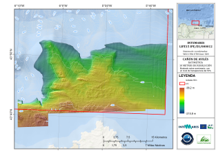
La información contenida en este conjunto de datos es un ráster de la batimetría de la zona con una resolución de 200 m, con profundidades comprendidas entre 36 y 216 m. La zona que comprende los datos proporcionados corresponde a un sector de la plataforma continental del Sistema de cañones submarinos de Avilés. Los datos brutos que constituyen este ráster se adquirieron durante los años 2010, 2011 y 2012, gracias a las campañas oceanográficas INDEMARES AVILÉS 0410 y 0511, a bordo del B/O Vizconde de Eza, INDEMARES AVILÉS 0412, a bordo del B/O Ramón Margalef e INDEMARES AVILÉS 0912 a bordo del B/O Ángeles Alvariño. Durante 2019 y 2020 se reprocesaron los datos con las últimas técnicas disponibles en software de procesado y se adquirieron nuevos modelos digitales de elevación, mejorando la resolución espacial y la calidad de los datos. La información geográfica recogida se almacena en una base de datos espaciales. Los trabajos de reprocesado se han financiado gracias al Proyecto LIFE IP INTEMARES (LIFE-IP INTEMARES - Integrated, Innovative and Participatory Management for N2000 network in the Marine Environment - LIFE15 IPE/ES/000012). Este proyecto integrado tiene el reto de sentar las bases para gestionar de forma eficaz los espacios marinos de la Red Natura 2000 y completar los trabajos y avances impulsados en el marco del proyecto LIFE+ INDEMARES, que logró dar un gran paso en materia de declaración de nuevos espacios.
-
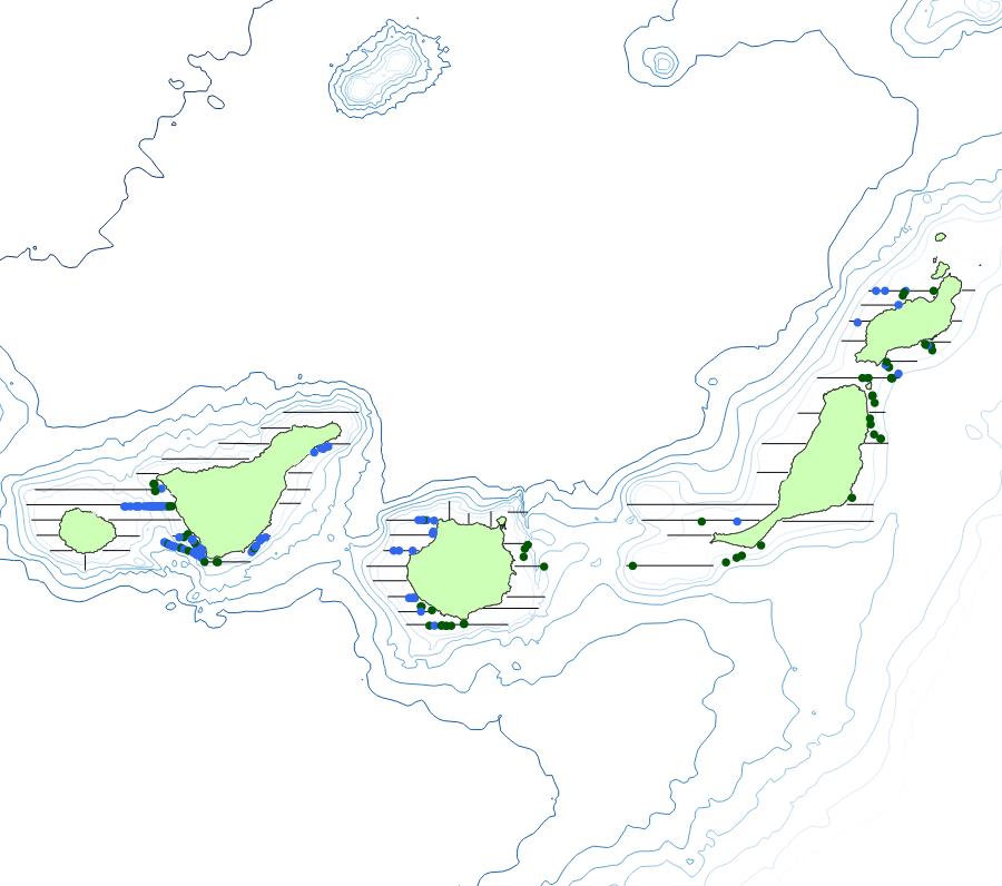
La información contenida en este conjunto de datos es referida a la campaña PECAN0221 llevada a cabo entre el 21 de febrero y 9 de marzo del año 2021. Se trata de la representación de la distribución espacial de las observaciones de actividades humanas (basuras y embarcaciones) recogidas durante los periodos con esfuerzo de muestreo. La zona que comprenden los datos proporcionados abarca la plataforma continental de las Islas Canarias (DMCAN). Se trata de un conjunto de datos compuesto por entidades puntuales, donde cada elemento representa observaciones de actividades humanas (basuras y embarcaciones) recogidos durante los periodos de la campaña con esfuerzo de muestreo. Cada objeto tiene asociada una serie de variables alfanuméricas como son: área de estudio, transecto,segmento, campaña,latitud, longitud, fecha, hora, grupo, número de avistamiento, código, descripción, código MSFD (correspondiente con el listado oficial de MSFD), número de grupo y observaciones. La elaboración de este conjunto de información geográfica comenzó en el año 2021, gracias a la participación del grupo de mamíferos marinos del IEO en la campaña. La información geográfica recogida se almacena en una base de datos espaciales. Estos trabajos se han financiado gracias al Proyecto “Asesoramiento Científico Técnico para la Protección del Medio Marino: Evaluación y Seguimiento de las Estrategias Marinas, seguimiento de los espacios marinos protegidos de competencia estatal (2018-2024)”. Las Estrategias Marinas son el instrumento de planificación del medio marino creado al amparo de la Directiva 2008/56/CE (modificada mediante la Directiva UE 2017/845) por la que se establece un marco de acción comunitaria para la política del medio marino (Directiva Marco sobre la Estrategia Marina), y tienen como principal objetivo, la consecución del Buen Estado Ambiental (BEA) de nuestros mares. Los 11 descriptores del Buen Estado Ambiental constituyen la base en que se sustenta la descripción y la determinación del buen estado ambiental del medio marino. Son establecidos por la Directiva en su anexo I. Las áreas marinas de evaluación se localizan dentro de las Demarcaciones Marinas definidas en el marco de las Estrategias Marinas de España, siendo estas Demarcaciones Marians las unidades utilizadas para la notificación a la Comisión Europea (Marine reporting units - MRU).
-
La información contenida en este conjunto de datos es el posicionamiento de los perfiles obtenidos con sonda paramétrica TOPAS PS018 durante la campaña CIRCASUR2020, en las aguas de la demarcación sudatlántica. Se trata de la representación de la distribución espacial de las líneas donde se tienen perfiles verticales del sustrato. La zona que comprenden los datos proporcionados abarca aguas del Golfo de Cádiz. Se trata de un conjunto de datos compuesto por elementos lineales, donde cada elemento representa la situación del perfil acústico obtenido con la ecosonda paramétrica TOPAS. La elaboración de este conjunto de información geográfica comenzó en octubre de 2020, gracias la campaña oceanográfica CIRCASUR2020. La información geográfica recogida se almacena en una base de datos espaciales. Estos trabajos se han financiado gracias al Proyecto “Asesoramiento Científico Técnico para la Protección del Medio Marino: Evaluación y Seguimiento de las Estrategias Marinas, seguimiento de los espacios marinos protegidos de competencia estatal (2018-2024)”. Las Estrategias Marinas son el instrumento de planificación del medio marino creado al amparo de la Directiva 2008/56/CE (modificada mediante la Directiva UE 2017/845) por la que se establece un marco de acción comunitaria para la política del medio marino (Directiva Marco sobre la Estrategia Marina), y tienen como principal objetivo, la consecución del Buen Estado Ambiental (BEA) de nuestros mares. Los 11 descriptores del Buen Estado Ambiental constituyen la base en que se sustenta la descripción y la determinación del buen estado ambiental del medio marino. Son establecidos por la Directiva en su anexo I. Las áreas marinas de evaluación se localizan dentro de las Demarcaciones Marinas definidas en el marco de las Estrategias Marinas de España, siendo estas Demarcaciones Marians las unidades utilizadas para la notificación a la Comisión Europea (Marine reporting units - MRU).
-
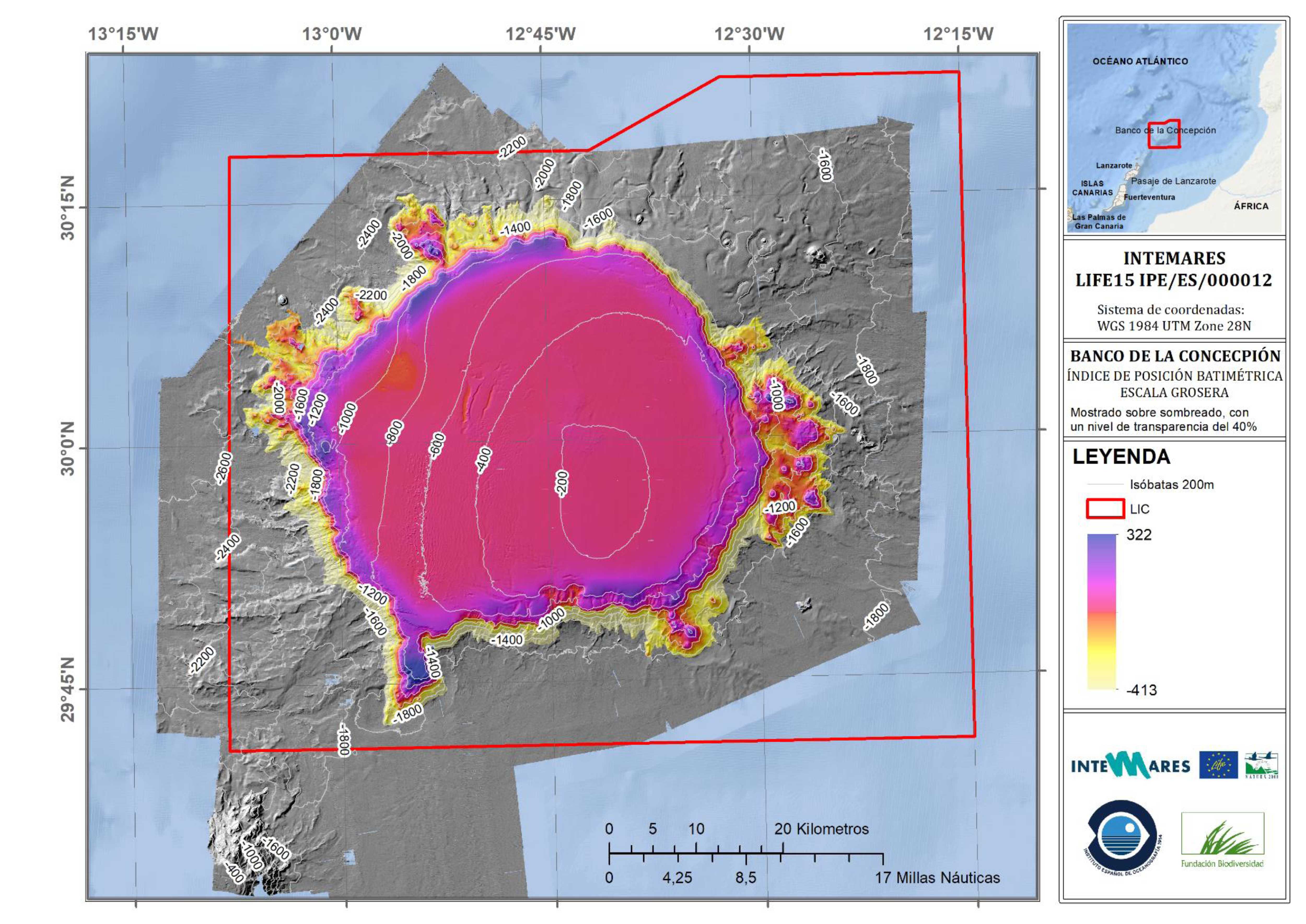
La información contenida en este conjunto de datos es un ráster con el Índice de Posición Batimétrica (BPI) de escala gruesa de la zona de estudio, a una resolución de 15 m. La zona que comprende los datos proporcionados corresponde al LIC Banco de la Concepción, situado en el noroeste de Lanzarote, perteneciente al archipiélago de las Islas Canarias e incluida en el LIC ESZZ15001. Los datos brutos que constituyen este ráster se adquirieron durante las campañas llevadas a cabo en el proyecto INDEMARES: INCOGEO_0310, INCOECO_0710, INCOECO_0611 e INCOECO_1012. Durante el proyecto INTEMARES se ha realizado el reprocesado de los datos batimétricos y de reflectividad disponibles, y se elaboraron nuevos modelos de elevación de la zona, a partir de los cuales se obtuvieron los Índices de Posición Batimétrica. La información geográfica recogida se almacena en una base de datos espaciales. Los trabajos de reprocesado se han financiado gracias al Proyecto LIFE IP INTEMARES (LIFE-IP INTEMARES - Integrated, Innovative and Participatory Management for N2000 network in the Marine Environment - LIFE15 IPE/ES/000012). Este proyecto integrado tiene el reto de sentar las bases para gestionar de forma eficaz los espacios marinos de la Red Natura 2000 y completar los trabajos y avances impulsados en el marco del proyecto LIFE+ INDEMARES, que logró dar un gran paso en materia de declaración de nuevos espacios.