 Catálogo de datos del IEO
Keyword
145
2139 record(s)
Type of resources
Categories
Topics
INSPIRE themes
Keywords
Contact for the resource
Provided by
Years
Formats
Status
-
Cr. CEE 90. Control of Phytoplankton Dominance. - ref 900911.0004
-
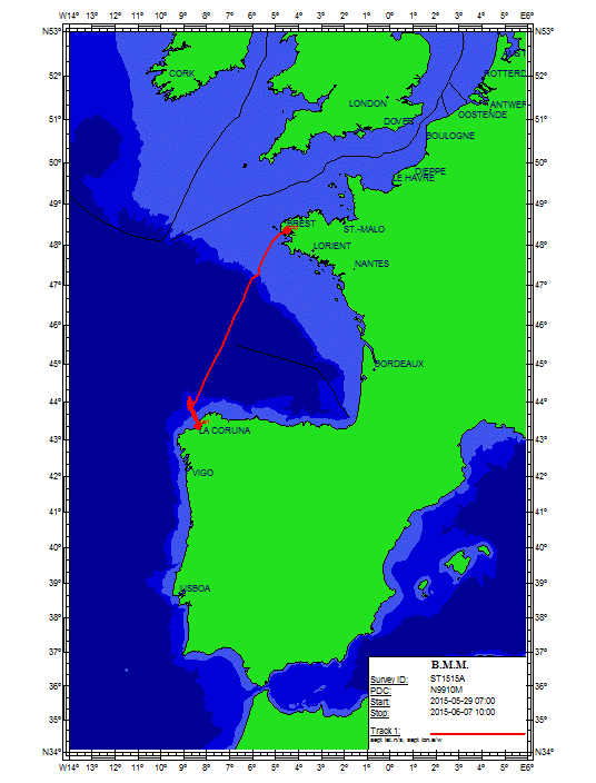
FWO MINIMOUND Project: Using Cold-water coral mini-mounds as analogue for giant mound growth: assessment of environmental drivers and anthropogenic impact Cold-water corals (CWC) are found along the entire north-eastern Atlantic Margin from Norway to the Gulf of Cadiz. In the Porcupine Seabight, these coral reefs (mainly Lophelia pertusa and Madrepora oculata) accumulate into large mounds of up to 250m high (e.g. Challenger Mound), which have been well studied over the past two decades (Roberts et al., 2006). The detailed mechanism of the start-up phase of such large CWC mounds is however not yet fully understood. Therefore, it is essential to study analogues of these stages that are not well recorded in larger mounds. The FWO MINIMOUND project (2013-2016) aims to investigate the initiation, growth and demise of small CWC mounds and to determine the role of climatic and hydrocarbon-seepage related processes as well as anthropogenic impact. This high-resolution multidisciplinary study will focus on three minimound provinces along the Biscay continental margin: (1) the Explorer and Dangeard Canyons on the Celtic Margin (Fig. 1; Stewart et al., 2013), (2) the Guilvinec Canyon on the Armorican Margin (De Mol et al., 2011) and (3) the Upper Ferrol Canyon on the Cantabrian Margin (Fig. 1). These minimounds are fossil (9.7 ka BP) and occur at relative shallow depth on the interface between the Eastern North Atlantic Central Water (ENACW) and the Mediterranean Outflow Water (MOW). Contrastingly, most present-day living CWC reef habitats dwell in the deeper MOW depth range, relying on the density and dynamics of this water mass for their food supply.   The objectives of the project are threefold: (1) the establishment of a chronostratigraphic framework and the reconstruction of palaeoceanographic changes over the last 15.000 years in order to determine the impact of glacial to interglacial climate change on the ENACW-MOW interface and the CWC habitats (Frank et al., 2011); (2) the minimound province at the Upper Ferrol Canyon shows a close association with hydrocarbon-seepage (pockmarks) which allows to assess the role of hydrocarbon related processes in CWC mound formation; (3) the potential impact of anthropogenic fisheries activities will be investigated. These objectives will be tackled through a coupled geophysical, sedimentological and integrative approach, including the palaeoceanographic and biogeochemical study of sediment cores in cooperation with the BGS (UK), LSCE (Gif-sur-Yvette, France), IFREMER (France), IGME (Spain) and IEO (Spain). This Belgica2015/15 cruise is the second campaign of the project and it aims to sample both on-mound as off-mound sites by means of a 4.5 m vibrocorer (Supplied by the British Geological Survey, BGS). The target site are located on the upper slopes of the Ferrol Canyon (Cantabrian margin, Spanish EEZ) and the Guilvinec Canyon (Armorican margin, French EEZ) between 200 and 600 m water depth. In each sector, a minimum of 3 days of activities will be scheduled. In case of bad weather on 1 sector, the program will be revised towards the other sector. With respect to the size of these mounds, the coring location of the vibrocorer will be steered by means of am IXSEA USBL GAPS system. During night-time, the seafloor will be visually characterized using a small and light-weight camera dropframe (University of Plymouth).
-

- Exploraciones geofisicas que permitan determinar su constitucion y fisiografia\n- Estudio de procesos fisicos\n- Procesado y tratamiento de datos, para la obtencion de mapas, cartas e informes\n- Estudio de batimetria, geomorfologia, gravimetria, magnetometria y calidades de sedimentos superficiales de las zonas estudiadas
-

La creciente necesidad de informacion que requiere la evaluacion y gestion actuales de las especies explotadas, especialmente en el caso de la merluza, pero tambien en otros como los gallos, rapes o la cigala, hacen necesario obtener informacion independiente de las pesquerias sobre la situacion de estas poblaciones. Para lo cual se determino la realizacion de los siguientes objetivos:\nEstimacion de indices de abundancia estratificados por edad de merluza, rapes y gallos en las divisiones VIIbk.\nEstimacion de indices de abundancia estratificados de otras especies comerciales como la cigala, el mendo, las rayas o la brotola de fango.\nEstimacion de la fuerza de los reclutamientos y localizacion de las agregaciones de juveniles de merluza, rapes y gallos.\nDescripcion de los patrones de distribucion espacial de las especies demersales y bentonicas en el banco de Porcupine.\nObtencion de muestras de especies comerciales para estudios de niveles de contaminacion por arsenico y metales pesados.\nRecogida de muestras de especies para el estudio de la biologia de las principales especies comerciales en el area (otolitos, ilicios y otros).\nEstudio de la hidrografia (temperatura, salinidad y densidad de la columna de agua) del banco de Porcupine.\nMarcado de rapes para el estudio de sus migraciones y crecimiento.\nRecogida de ejemplares de jurel para estudios de genetica.
-
- LEVANTAMIENTO MORFOLOGICO DETALLADO DEL FONDO MARINO, MEDIANTE UN RECONOCIMIENTO DE LAS ZONAS DE ESTUDIO REALIZADO CON ECOSONDA MAULTIHAZ\n- CONOCIMIENTO DE LAS CARACTERISTICAS SEDIMENTARIAS DEL SUELO Y SUBSUELO MARINO MEDIANTE LA REALIZACION DE PERFILES SISMICOS DE ALTA RESOLUCIONCON EL SISTEMA DE SONDA PARAMETRICA TOPAS\n- PROSPECCION DE POSIBLES RESTOS DE POSIBLES RESTOS DE FUEL ENTRE DOS AGUAS MEDIANTE ECOSONDA HIDROGRAFICA\n- IDENTIFICACION Y MAPEADO DE AREAS DE DEPOSICION DE FUEL MEDIANTE EL RECONOCIMIENTO DEL AREA DE ESTUDIO CON SONAR DE BARRIDOLATERAL CON PRESTACIONES DE ALTA FRECUENCIA, MAYOR RESOLUCION Y MOSAICOS DE REFLECTIVIDAD OBTENIDOS CON ECOSONDA MULTIHAZ\n- RECOGIDA DE MUESTRAS DE ROCA Y SEDIMENTOS DE FUEL UTILIZANDO PARA ELLO DRAGA DE ROCA\n- TOMA DE DATOS
-
Caracterizacion fisica, biogeoquimica y de produccion planctonica Estudio de los frentes costeros que delimitan los ambientes.
-
Mejorar el conocimiento de la Hidrografia, circulacion costera de la plataforma continental N-NW de la Peninsula Iberica.\nConocimiento de la abundancia y condicion de las larvas de cupleidos.\nRelacion entre condiciones oceanograficas y supervivencia de las larvas
-
Abundance indices, distribution patterns and faunal assemblages of demersal species in the northern coast of Spain (Atlantic Galician shelf and Cantabrian sea shelf), together with the possible driving factors of their distribution. This survey belongs to the research project: ?Evaluacion de Recursos Demersales por Metodos Directos en el Area ICES?. This Project is partly funded by the DCR of the EU and the Education and Science Spanish Ministery.The main objectives of the above mentioned project related with this survey time series are: a) to obtain abundance indices of the main exploited species in the study area; b) to estimate the strength of yearly recruitments of these species and their distribution in the area. c) to study the structure and distribution o the demersal and benthic communities in the area.
-
CR SEFOS-0595 ICES Mackerel/Horse Mackerel Egg Production Survey - ref SEFOS0595
-
OBTENCION DE BALANCES DE MASA ENTRE NUTRIENTES PRODUCCION PLANCTONICA Y EXPORTACION DE MATERIALES AL SEDIMENTO EN LA COSTA NO DE LA PENINSULA IBERICA EN RELACION AL AFLORAMIENTO ESTACIONAL.\nOBTENCION DE MEDIDAS DE LA ESTRUCTURA HIDROGRAFICA SUPERFICIAL, CONCENTRACIONES DE NUTRIENTES Y BIOMASA PLANCTONICA, EN LA ZONA DEL TALUD CONTINENTAL DE GALICIA, A AMBOS LADOS DEL FRENTE DEMIPERMANENTE DE CABO FINISTERRE