 Catálogo de datos del IEO
Keyword
single-channel seismic reflection systems
31 record(s)
Type of resources
Categories
Topics
INSPIRE themes
Keywords
Contact for the resource
Provided by
Years
Formats
Status
-
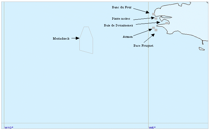
<p>Technical trials for NAUTILE, SYSIF, SMF RESON, GAPS and MATS equipment. The trials cruise had 2 legs: Leg 1 from 04/05/09 to 15/05/09 (Brest - La Coruna) and Leg 2 from 16/05/09 to 19/05/09 (La Coruna - Funchal).</p>
-

Swath bathymetry, high definition seismic reflection and habitat mapping of the insular shelf of Menorca.
-
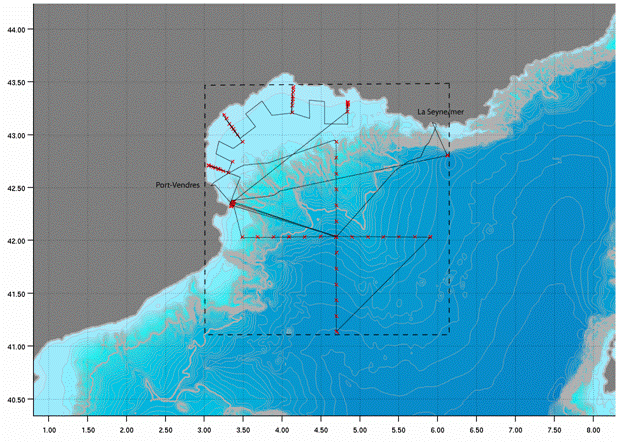
<p>The deep basin and continental shelf of the Gulf of Lion (North Western Mediterranean) are known for the formation of dense water in wintertime by the action of N-NW continental winds. This dense water is formed both offshore and at the coast. The area of Cap de Creus and its adjacent canyon is the main zone where dense coastal water is exported. Dense water dynamics on the continental shelf are also influenced by E-SE storms. Transfers of organic, inorganic, particulate and dissolved matter from the surface to the deep basin and from the shelf towards the slope by these physical processes can influence the redistribution of chemical elements in sediments, as well as the structure and functioning of benthic and pelagic ecosystems. The CASCADE cruise aimed to determine the characteristics of these two physical mechanisms and their numerous impacts, as well as monitoring changes in the hydrology, dynamics, sedimentology and biogeochemistry of water bodies. We propose a qualitative and quantitative estimate of particulate and dissolved, organic and inorganic matter fluxes exported towards the slope and the deep basin by these mechanisms.</p>
-
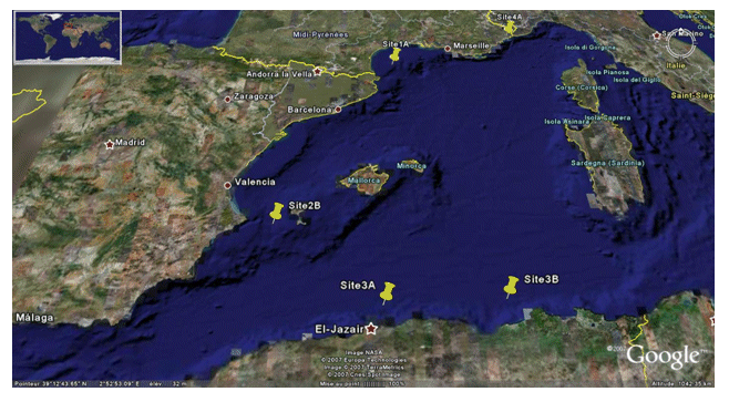
<p>The PRISME cruise objectives were to: - quantify the risk of earthquake-induced sedimentary liquefaction (for areas studied on the Algerian margin and slope off Nice, France); - quantify the risk of instability and failure due to loss of resistance in sensitive clay (slope off Nice); - quantify the risk of slope breaks and erosion caused by bottom currents (canyon heads - gulf of Lion); - identify the triggering factors for slides seen off Ibiza; - and begin to identify the turbidity related to seismic activity along the Algerian margin. This falls under the ANR-Isis an dGDR Marges projects. The cruise took place on 5 sites: Site 1A - Gulf of Lion - North: N 42° 50.00' South: N 42° 40.00' West: E 003° 35.00' East: E 004° 0.00' / Site 2B - Ibiza channel - North: N 38° 39.00' South: N 38° 37.50' West: E 000° 47.00' East: E 000° 51.00' / Site 3A - Alger - North: N 37° 30.00' South: N 36° 40.00' West: E 002° 00.00' East: E 004° 00.00' / Site 3B - Djijel North: N 37° 30.00' South: N 37° 00.00' West: E 005° 00.00' East: E 004° 00.00' / Site 4A - Djijel North: N 43° 40.00' South: N 43° 38.00' West: E 007° 12.00' East: E 007° 15.00'.</p>
-

<p>?The cruise took place from 22 November to 20 December 2006 aboard RV L'Atalante. Its objective was to study the formation of passive continental margins and a special sedimentary sequence which exists all over the Mediterranean. The result of national (IUEM Brest, Géosciences Azur, University of Lille, UPMC) and European (Universities of Lisbon and Bologna, GEOMAR and AWI) cooperation, directed by Ifremer, the cruise mobilized some twenty scientists for nearly one month. The related project is GDR Marges.</p>
-

They focus on the seabed research of Mediterranean sea (Spain ), both indirect and direct. Carry out a survey of the fishing beaches to later elaborate fishing charts. Systematic bathymetric survey of the study areas with 100% coating (Multi-beam echo sounder EM-300). seismic profiles according to the ship's defeat (Topas 710 system). Performance of sound velocity profiles in the water column. Side sweep sonar in selected areas. Sediment sampling (Shipeck dredges - Box corer). Sampling of Rocky Outcrops (Rock Dredge).
-
They focus on the seabed research of Atlantic ocean (Galicia, Spain ), both indirect and direct. Carry out a survey of the fishing beaches to later elaborate fishing charts. Systematic bathymetric survey of the study areas with 100% coating (Multi-beam echo sounder EM-300). seismic profiles according to the ship's defeat (Topas 710 system). Performance of sound velocity profiles in the water column. Side sweep sonar in selected areas. Sediment sampling (Shipeck dredges - Box corer). Sampling of Rocky Outcrops (Rock Dredge).
-
They focus on the seabed research of Mediterranean sea (Spain ), both indirect and direct. Carry out a survey of the fishing beaches to later elaborate fishing charts. Systematic bathymetric survey of the study areas with 100% coating (Multi-beam echo sounder EM-300). seismic profiles according to the ship's defeat (Topas 710 system). Performance of sound velocity profiles in the water column. Side sweep sonar in selected areas. Sediment sampling (Shipeck dredges - Box corer). Sampling of Rocky Outcrops (Rock Dredge).
-
They focus on the seabed research of EEZ Canarias (Spain ), both indirect and direct. Carry out a survey of the fishing beaches to later elaborate fishing charts. Systematic bathymetric survey of the study areas with 100% coating (Multi-beam echo sounder EM-300). seismic profiles according to the ship's defeat (Topas 710 system). Performance of sound velocity profiles in the water column. Side sweep sonar in selected areas. Sediment sampling (Shipeck dredges - Box corer). Sampling of Rocky Outcrops (Rock Dredge).
-

LASEA campain from project CGL2011-30302-C02 has the following objectives: Phase 1: Acquire bathymetric and seismic data from the gulf of Cadiz using acoustic echo sounders EM710, TOPAS and Sparker. Phase 2: Obtain sediment samples from the gulf of Cadiz and complementary bathymetric data.