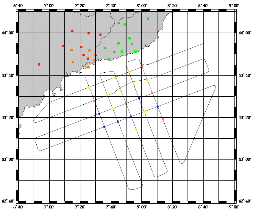
Coinciding with the development of the project, Friday, April 2, 500 days have passed since a 26-year-old monocoque tanker, loaded with 77,000 tons of fuel, split in two. The Prestige sank 260 km from the Cies Islands, in the Vigo estuary, generating a first spot of 5,000 tons of fuel. This campaign analyzes the effects produced by the spillage of the Prestige hydrocarbon on the ecosystem of the continental shelf of Galicia. OBJECTIVES Multidisciplinary campaign that monitored the impact of oil spills on demersal and benthic communities in funds between 70 and 500 m. Likewise, the geophysical study of the worst known areas of the platform was undertaken, such as the rocky areas, which are, nevertheless, of great ecological and commercial importance, and possible areas of sedimentary deposit that can be points of accumulation and retention of fuel
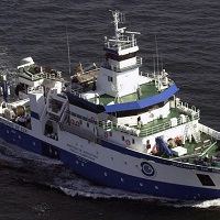
The oceanographic vessel Vizconde de Eza developed its first research campaign in Galicia as a result of the unfortunate accident and sinking of the Prestige oil tanker. In January of 2003, this project was undertaken to estimate the impact produced by the discharge of hydrocarbon on the demersal communities on the continental shelf of Galicia, in soft bottoms between 90 and 500 m, testing new acoustic methods for the detection of fuel the depths fixed. This multidisciplinary campaign took place over eight days on board the B / O Vizconde de Eza in the area of the continental shelf between the Ría de Muros and La Coruña. The study of the main members of the bottom communities (infauna, epifauna, suprabenths and benthic and demersal macrofauna) was included, for which 20 sampling stations were established located in the three strata of the standardized trawl campaigns (70 - 120, 121 - 200 and 201 - 500 meters).
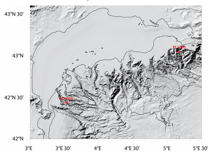
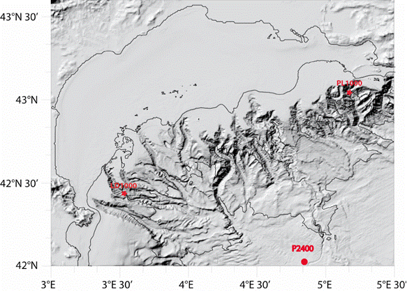
Characterizing the variability of hydrology and currentology features and particulate fluxes in the two canyons of Planier (station PL1000) and Lacaze-Duthiers (station LD1000), located at the eastern and western edges of the Gulf of Lion.
Characterizing the variability of hydrological and current measurement features and particulate fluxes in two canyons of Le Planier (station PL1000) and Lacaze-Duthiers (station LD1000) located at the easternmost and westernmost tips of the Gulf of Lion.
The main objective of the MOOSE-GE cruises is to observe the annual evolution of the Northwestern Mediterranean Sea in the context of the climate change and anthropogenic pressure in order to be able to detect and identify long-term environmental trend and anomalies of the marine ecosystem. The annual cruise focuses on moorings maintenance and hydrology, biogeochemistry and biology monitoring of the Northwestern Mediterranean basin. It aims to follow variability of water masses properties (LIW and WMDW) and biogeochemical and biological content related to these water masses.
This third investigation of the spillage of fuel in waters of Galicia and the Cantabrian Sea intended to continue the study of the impact of oil spills. In this edition, the monitoring of the process of recovery of ecosystems and exploited resources involved a study during spring flowering, period of higher production, to quantify the changes in the patterns of distribution and abundance of the communities. This campaign of 'evaluation of the impact of the Prestige discharges on the ecosystem of the platform and its fishing resources in spring time' was attended by researchers from the IEO, SGPM and CSIC. GOALS The general objective was to estimate the impact produced by the Prestige discharge on the demersal and benthic communities present on the continental shelf of Galicia, in soft bottoms between 35 and 500 meters. These communities are subject to considerable fishing exploitation and sustain the economy of numerous coastal towns of Galicia and the Cantabrian Sea. At the same time, geophysical studies were included, aimed at improving the knowledge of the funds of the internal platform, essential for carrying out sampling operations. The study was articulated around the following objectives: WORK AREA A multidisciplinary campaign of 16 days was proposed in the area of the platform between the Ría de Vigo and the mouth of the Bidasoa river. The study was conducted in affected areas of the continental shelf of Galicia and the Cantabrian Sea in funds between 35 and 500 m. To this end, a series of sampling stations arranged in radials and located in five geographical sectors and three depth layers (71-120, 121-200 and 201-500 m) were established, which corresponded to those of the historical series of survey campaigns. of the IEO (following figure). In areas of special interest due to the importance of the discharges, hauls were made at less than 70 m.
<p style="text-align:justify">The main objective of the observing system MOOSE certified as « SNO INSU », integrated in « IR ILICO » and recently re-certified as SNO for 2020-2024 is to monitor the long-term evolution of the north-western Mediterranean Sea (over more than 10 years) in the context of climate change and anthropogenic pressure in order to detect and identify the trend and environmental anomalies of the marine ecosystem. The MOOSE network aims to establish an integrated and multidisciplinary system in the Mediterranean Sea in accordance with the objectives of the national MISTRALS program (HyMeX, MeRMEX and ChARMeX). The MOOSE system is supported by national institutes (CNRS-INSU, French Ministry of Higher Education and Research) and involved different partners (Universities, IFREMER, Meteo France).</p> <p style="text-align:justify">The MOOSE network includes "multi-scale" measurement capabilities to accurately document the broad spectrum of hydrodynamic processes already identified (large scale circulation, (sub)mesoscale eddies, biogeochemical provinces). High temporal resolution measurements are obtained from fixed observatories (moorings, buoys) but their spatial distribution remains insufficient. Spatial variability is of the same order as temporal variability and understanding the evolution of this basin as a whole implies being able to dissociate both. Synergy with other strategies (ships, floats, gliders) is essential for the establishment of an optimized observation network in such a system. To address the issues identified by MOOSE, two key areas of the north-western basin have been identified:</p> <ul> <li style="text-align: justify;">The central and western part of the Ligurian Sea, which constitutes a homogeneous system isolated from direct coastal inputs by rivers and where atmospheric inputs are predominant (DYFAMED and ANTARES). It is also one of the entrance passages of the Intermediate Levantine Water (LIW) in the north-western Mediterranean basin.</li> <li style="text-align: justify;">The central area of the Gulf of Lion where winter cooling leads to vertical mixing over 2000 m and sometimes to the bottom. The LION site (42°N 5°E) is ideal for studying the variability of winter convection to better understand mixing processes and dense water formation. It also characterizes the variability of the deep particle flow.</li> </ul> <p style="text-align:justify">Currently, fixed observation at these sites is carried out by 5 moorings:</p> <ul> <li style="text-align: justify;">The Planier and Lacaze-Duthiers moorings composed of sediment traps and T/S sensors and current meters, for dense water cascading and particle export studies. These moorings have been set up since 1994 and managed by CEFREM.</li> <li style="text-align: justify;">The LION mooring, consisting of a large number of T/S sensors, current meters, and two oxygen sensors, is in the Gulf of Lion convection zone. It has been deployed since 2007, and is managed by CEFREM and LOCEAN. The LIONCEAU mooring that was positionned nearby with a sediment trap near the bottom has been integrated into the LION mooring in 2019.</li> <li style="text-align: justify;">The ANTARES mooring is located in the North Current off Toulon and equipped with T/S sensors, current meters and oxygen sensors to quantify the bacteria activity and organic matter remineralization process in a deep marine environment. It exists since 2004, it is managed by the M.I.O. and the CPPM (Marseille). This mooring is part of the ERIC EMSO since 2017.</li> <li style="text-align: justify;">The DYFAMED mooring, in the Ligurian Sea, equipped with sediment traps, T/S sensors, current meters and oxygen sensors to monitor the evolution of the water column, the impact of atmospheric dust deposition and marine particles export to deep waters. It exists since 1988, it is currently managed by the Oceanological Observatory of Villefranche-sur-Mer.
<p>The annual MOOSE-GE campaigns, initiated in 2010, are part of the network long-term observation of the Mediterranean, MOOSE, SOERE Allenvi and SNO labelled network by the INSU. The objective of this observation network is to monitor the long-term evolution of the North-Western Mediterranean in the context of climate change and anthropogenic pressure, in order to be able to detect and identify the trend of environmental anomalies of this marine ecosystem. MOOSE aims to maintain an integrated observation network and multidisciplinary in the Mediterranean Sea in accordance with the objectives of the MISTRALS programmes (HyMeX, MERMeX and ChArMEx).</p> <p style="text-align:center"><img alt="" src=" https://campagnes.flotteoceanographique.fr/campagnes/18000442/images/444.jpg" style="width: 500px; height: 294px;"></p>
<p style="text-align:justify">The main objective of the observing system MOOSE is to monitor the long-term evolution of the north-western Mediterranean Sea (over more than 10 years) in the context of climate change and anthropogenic pressure in order to detect and identify the trend and environmental anomalies of the marine ecosystem. The MOOSE network aims to establish an integrated and multidisciplinary system in the Mediterranean Sea in accordance with the objectives of the national MISTRALS program (HyMeX, MeRMEX and ChARMeX). The MOOSE system is supported by national institutes (CNRS-INSU, French Ministry of Higher Education and Research) and involved different partners (Universities, IFREMER, Meteo France).</p> <p style="text-align:justify">The MOOSE network includes "multi-scale" measurement capabilities to accurately document the broad spectrum of hydrodynamic processes already identified (large scale eddies, mesoscale eddies, biogeochemical provinces). High temporal resolution measurements are obtained from fixed observatories (moorings, buoys) but their spatial distribution remains insufficient. Spatial variability is of the same order as temporal variability and understanding the evolution of this basin as a whole implies being able to dissociate both. Synergy with other strategies (ships, floats, gliders) is essential for the establishment of an observation network in such a system. To address the issues identified by MOOSE, two key areas of the north-western basin have been identified:</p> <ul> <li style="text-align:justify">The central and western part of the Ligurian Sea, which constitutes a homogeneous system isolated from direct coastal inputs by rivers and where atmospheric inputs are predominant (DYFAMED and ANTARES). It is also one of the entrance passages of the Intermediate Levantine Water (LIW) in the north-western Mediterranean basin.</li> <li style="text-align:justify">The central area of the Gulf of Lion where winter cooling leads to vertical mixing over 2000 m and sometimes to the bottom. The LION site (42°N 5°E) is ideal for studying the variability of winter convection to better understand mixing processes and dense water formation. It also characterizes the variability of the deep particle flow.</li> </ul> <p style="text-align:justify">Currently, fixed observation at these sites is carried out by six moorings:</p> <ul> <li style="text-align:justify">The Planier and Lacaze-Duthiers moorings composed of sediment traps and T/S sensors and current meters, for dense water cascading and particle export studies. These moorings have been set up since 1994 and managed by CEFREM.</li> <li style="text-align:justify">The LION mooring, consisting of a large number of T/S sensors, current meters, and two oxygen sensors, is in the Gulf of Lion convection zone. It has been deployed since 2007, and is managed by CEFREM and LOCEAN. A sediment trap near the bottom has also been present for 2 years in this area (LIONCEAU mooring). The latter will be integrated into the LION mooring in 2019.</li> <li style="text-align:justify">The ANTARES mooring is located in the North Current off Toulon and equipped with T/S sensors, current meters and oxygen sensors to quantify the bacteria activity and organic matter remineralization process in a deep marine environment. It exists since 2004, it is managed by the M.I.O. and the CPPM (Marseille). This mooring is part of the ERIC EMSO since 2017.</li> <li style="text-align:justify">The DYFAMED mooring, in the Ligurian Sea, equipped with sediment traps, T/S sensors, current meters and oxygen sensors to monitor the evolution of the water column, the impact of atmospheric dust deposition and marine particles export to deep waters. It exists since 1988, it is currently managed by the Oceanological Observatory of Villefranche-sur-Mer. This mooring is part of the ERIC EMSO since 2017.
Monthly survey to study thermohaline and biological characterization of water masses in the East-North Atlantic.