 Catálogo de datos del IEO
Keyword
L'Atalante
14 record(s)
Type of resources
Categories
Topics
INSPIRE themes
Keywords
Contact for the resource
Provided by
Years
Formats
Status
-
<p style="text-align:justify">SHOM cruise with implementation of the MVP.</p>
-
Charter cruise with the objective of validating the performance of SERCEL equipment, i.e. evaluation of different seismic devices and validating this equipment.
-
<p>The WESTMEDFLUX-2 oceanographic cruise is part of the project that studies the presence of thermal anomalies in the ocean-continent transitions of the Western Mediterranean. The proposed cruise follows WESTMEDFLUX that took place in 2016 and that resulted in mapping regional trends of thermicity in in the Gulf of Lion, offshore Baleares and Sardinia. It also pointed out to the existence of several local heat flow anomalies in particular on the South Balearic slope and deep basin. In the deep oceanic basin, strong anomalies seem to be merely associated to salt diapiric structures, but on the rifted continent and transition zone, other heat sink and sources are suggested (e.g., bottom water currents, slope instabilities and focused fluid migrations). In order to better understand the source of these anomalies and the link with the crustal nature and structuring of the margin, we propose on the South-Balearic margin additional close-spaced heat flow measurement, sediment coring and dredging sites. Sediment cores will be used for turbidite and contourite studies and for geochemical analysis of pore fluids. The dredging operations aim an estimation of age and nature of volcanic rock material from sea mounts.</p>
-
<p>The Protevs Med 2017 campaign aimed to explore the area of the northern Balearic front and the southern edge of the convection area of the north western basin at the end of winter when convection events are most likely. Sampling to target small mesoscale structures detectable by altimetry but also even smaller structures that did not sign on altimetry.</p> <p>A particular focus was placed on an anticyclonic structure in the southern Balearic Islands that is systematically detectable by altimetry but which appears to be an artifact.</p> <p>Finally, the edge of the Catalan shelf was explored at high resolution.</p>
-
<p>The Protevs Med 2017 campaign aimed to explore the area of the northern Balearic front and the southern edge of the convection area of the north western basin at the end of winter when convection events are most likely. Sampling to target small mesoscale structures detectable by altimetry but also even smaller structures that did not sign on altimetry.</p> <p>A particular focus was placed on an anticyclonic structure in the southern Balearic Islands that is systematically detectable by altimetry but which appears to be an artifact.</p> <p>Finally, the edge of the Catalan shelf was explored at high resolution.</p> <p> </p>
-
The main objective of the MOOSE-GE cruises is to observe the annual evolution of the Northwestern Mediterranean Sea in the context of the climate change and anthropogenic pressure in order to be able to detect and identify long-term environmental trend and anomalies of the marine ecosystem. The annual cruise focuses on moorings maintenance and hydrology, biogeochemistry and biology monitoring of the Northwestern Mediterranean basin. It aims to follow variability of water masses properties (LIW and WMDW) and biogeochemical and biological content related to these water masses.
-
<p>The purpose of WestMedFlux is to study thermal fields in ocean-continent transition zones in the Western Mediterranean, and the role of fluids and salt diapirs on the thermal field.</p>
-
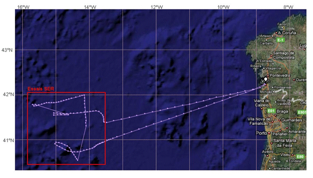
Technological trials run on seismic equipment developed by the SERCEL firm.
-
<p>The annual MOOSE-GE campaigns, initiated in 2010, are part of the network long-term observation of the Mediterranean, MOOSE, SOERE Allenvi and SNO labelled network by the INSU. The objective of this observation network is to monitor the long-term evolution of the North-Western Mediterranean in the context of climate change and anthropogenic pressure, in order to be able to detect and identify the trend of environmental anomalies of this marine ecosystem. MOOSE aims to maintain an integrated observation network and multidisciplinary in the Mediterranean Sea in accordance with the objectives of the MISTRALS programmes (HyMeX, MERMeX and ChArMEx).</p> <p style="text-align:center"><img alt="" src=" https://campagnes.flotteoceanographique.fr/campagnes/18000442/images/444.jpg" style="width: 500px; height: 294px;"></p>
-
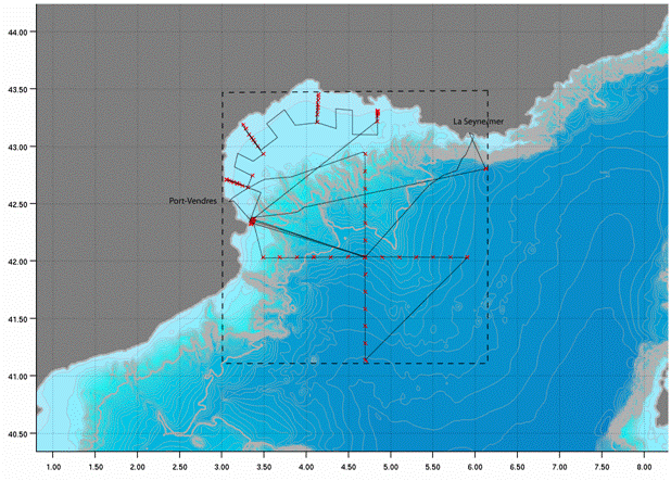
<p>The deep basin and continental shelf of the Gulf of Lion (North Western Mediterranean) are known for the formation of dense water in wintertime by the action of N-NW continental winds. This dense water is formed both offshore and at the coast. The area of Cap de Creus and its adjacent canyon is the main zone where dense coastal water is exported. Dense water dynamics on the continental shelf are also influenced by E-SE storms. Transfers of organic, inorganic, particulate and dissolved matter from the surface to the deep basin and from the shelf towards the slope by these physical processes can influence the redistribution of chemical elements in sediments, as well as the structure and functioning of benthic and pelagic ecosystems. The CASCADE cruise aimed to determine the characteristics of these two physical mechanisms and their numerous impacts, as well as monitoring changes in the hydrology, dynamics, sedimentology and biogeochemistry of water bodies. We propose a qualitative and quantitative estimate of particulate and dissolved, organic and inorganic matter fluxes exported towards the slope and the deep basin by these mechanisms.</p>