 Catálogo de datos del IEO
Keyword
Belgica
14 record(s)
Type of resources
Categories
Topics
INSPIRE themes
Keywords
Contact for the resource
Provided by
Years
Formats
Status
-
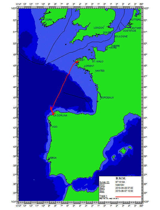
FWO MINIMOUND Project: Using Cold-water coral mini-mounds as analogue for giant mound growth: assessment of environmental drivers and anthropogenic impact Cold-water corals (CWC) are found along the entire north-eastern Atlantic Margin from Norway to the Gulf of Cadiz. In the Porcupine Seabight, these coral reefs (mainly Lophelia pertusa and Madrepora oculata) accumulate into large mounds of up to 250m high (e.g. Challenger Mound), which have been well studied over the past two decades (Roberts et al., 2006). The detailed mechanism of the start-up phase of such large CWC mounds is however not yet fully understood. Therefore, it is essential to study analogues of these stages that are not well recorded in larger mounds. The FWO MINIMOUND project (2013-2016) aims to investigate the initiation, growth and demise of small CWC mounds and to determine the role of climatic and hydrocarbon-seepage related processes as well as anthropogenic impact. This high-resolution multidisciplinary study will focus on three minimound provinces along the Biscay continental margin: (1) the Explorer and Dangeard Canyons on the Celtic Margin (Fig. 1; Stewart et al., 2013), (2) the Guilvinec Canyon on the Armorican Margin (De Mol et al., 2011) and (3) the Upper Ferrol Canyon on the Cantabrian Margin (Fig. 1). These minimounds are fossil (9.7 ka BP) and occur at relative shallow depth on the interface between the Eastern North Atlantic Central Water (ENACW) and the Mediterranean Outflow Water (MOW). Contrastingly, most present-day living CWC reef habitats dwell in the deeper MOW depth range, relying on the density and dynamics of this water mass for their food supply.   The objectives of the project are threefold: (1) the establishment of a chronostratigraphic framework and the reconstruction of palaeoceanographic changes over the last 15.000 years in order to determine the impact of glacial to interglacial climate change on the ENACW-MOW interface and the CWC habitats (Frank et al., 2011); (2) the minimound province at the Upper Ferrol Canyon shows a close association with hydrocarbon-seepage (pockmarks) which allows to assess the role of hydrocarbon related processes in CWC mound formation; (3) the potential impact of anthropogenic fisheries activities will be investigated. These objectives will be tackled through a coupled geophysical, sedimentological and integrative approach, including the palaeoceanographic and biogeochemical study of sediment cores in cooperation with the BGS (UK), LSCE (Gif-sur-Yvette, France), IFREMER (France), IGME (Spain) and IEO (Spain). This Belgica2015/15 cruise is the second campaign of the project and it aims to sample both on-mound as off-mound sites by means of a 4.5 m vibrocorer (Supplied by the British Geological Survey, BGS). The target site are located on the upper slopes of the Ferrol Canyon (Cantabrian margin, Spanish EEZ) and the Guilvinec Canyon (Armorican margin, French EEZ) between 200 and 600 m water depth. In each sector, a minimum of 3 days of activities will be scheduled. In case of bad weather on 1 sector, the program will be revised towards the other sector. With respect to the size of these mounds, the coring location of the vibrocorer will be steered by means of am IXSEA USBL GAPS system. During night-time, the seafloor will be visually characterized using a small and light-weight camera dropframe (University of Plymouth).
-
Campaign GENESIS 2 "Pen Duick/Melilla", the second of three ROV campaigns, will focus on "Pen Duick Escarpment" in the Gulf of Cadiz or on the recently discovered "Melilla mounds" in the South-East Alboran Sea (Mediterranean Sea). The final choice of the study area will depend on the results of the TTR17 cruise with R/V Logachev (June-July 2008) and the R/V Marion Dufresne cruise (June 2008). One of these study areas will be surveyed using multibeam, side-scan sonar and high resolution seismics. Based on this site survey, the ROV Genesis will be deployed to carry out detailed mapping. Also the hydrography and sediment dynamics of the area will be studied with respect to the steering of the present ecosystems. GENESIS 2 takes place in the framework of the European projects HERMES (EC FP6), MiCROSYSTEMS (ESF) and HERMIONE (EC FP7).
-
The area in between the Audierne and St. Nazaire canyons (Gascogne) along the Armorican margin was one of the areas where the "massifs coralliens" were described for the very first time. Within the framework of the HERMES (EC FP6), MiCROSYSTEMS (ESF) and GeNeSis (FWO) projects, this area will be surveyed using multibeam and high resolution seismics during LEG 1. Based on this site survey, the ROV Genesis will be deployed to carry out detailed mapping of these deep-water "hot-spots". Also the hydrography and sediment dynamics of this area will be studied with respect to the steering of the present ecosystems. LEG 2 will focus on the Galicia bank. This location has been assigned as reference area within the ESF project BIOFUN. In addition to a bathymetric and seismic surveying, also biological sampling and experiments are planned here.
-
The objectives of the BELMER project are: - to validate the MERIS water products for Belgian coastal waters and neighbouring French, UK and Dutch waters - to provide a quantitative statement of product accuracy and recommendations for improvements in the scientific algorithms, where appropriate. In particular the problems reported by the MERIS validation and user communities of turbid water atmospheric correction, case 2 water chlorophyll retrieval, adjacency effects (straylight), moderate sunglint, spatio-temporal variability of specific inherent optical properties and bottom reflectance will be addressed. This project is funded by the "PROgramme for the Development of scientific Experiments" (PRODEX) of the European Space Agency (ESA).
-
Our project aims at assessing the different biogeochemical processes controlling the nitrogen cycle in oligotrophic N.E. Atlantic waters. Our approach is based on the use of dual nitrate isotope measurements (natural abundance and enrichment experiments) to disentangle these various N processes in the marine environment, and in particular the process of diazotrophy by which atmospheric N2 is introduced into the oceanic fixed nitrogen reservoir. This input of "new" nitrogen should stand in balance with the denitrification process by which N is lost from the oceanic system. There are indications that the intensity as well as the geographical distribution of diazotrophic activity has been underestimated till date. Our observations, made the past few years, indicate that diazotrophic activity is present in the Azores Current region (DIAPICNA, EUROFLEET cruise; July 2011) and along a meridional section through the Atlantic Ocean (EUROPA cruise; European Universities & Research On board RV Polarstern in the Atlantic, Nov. 2012). During the EUROPA cruise maximal fixation rates were observed around 20°N, south of the Canary Islands, but diazotrophic activity was detected at all latitudes, even at 38°N , the northernmost station sampled during the EUROPA cruise. It is of interest to better document diazotrophic activity at latitudes of 38°N and northward. We propose to study the different biogeochemical processes acting on the marine N-cycle, including N2 fixation, along a N-S section through the Gulf of Biscay to Cape Finistere and further south in open ocean waters along the Iberian peninsula till about 36°30'N. On board we will measure primary production, N-nutrient uptake and N2 fixation in the euphotic layer, using 13C, 15N enriched incubation experiments. We also will sample the upper 1000m of water column for nutrient concentration and N-nutrient natural isotopic composition analyses. This investigation will be coupled with a newly started PhD project, financed by FNRS (Aspirant mandate) and in co-tutelle between ULB and VUB, aiming at studying the impact of the marine iron biogeochemistry on the phytoplankton and the diazotroph communities. During the campaign, we shall perform incubation experiments using in-situ oligotrophic surface waters to examine the influence of the addition of dissolved iron and that of natural desert dusts on the phytoplanktonic production and diazotrophic activity.The AUMS project is inspired by the success of similar systems deployed on various ships of opportunity in the framework of the European Union FerryBox project (www.ferrybox.org). The instrumentation will greatly enhance the continuous oceanographic measurements made by RV Belgica by taking advantage of the significant technological improvements since the design of the existing (salinity, temperature, fluorescence) systems. In particular, many new parameters can now be measured continuously including important ecosystem parameters such as nitrate, ammonia, silicate, dissolved oxygen and CO2, turbidity, alkalinity and phytoplankton pigments. In addition, the new equipment allows automatic acquisition and preservation of water samples, rendering RV Belgica operations significantly more efficient by reducing onboard human resources. Data will be available in near real-time via the public website of OD NATURE and following quality control, from the Belgian Marine Data Centre.Collection of GNSS data in the maritime environment for performance evaluation under different conditions.Aim of the project is to cultivate marine bacteria able to degrade hydrocarbons at both atmospheric and high pressure, in aerobic and anaerobic environments. Kill-Spill is an European funded FP7 project focusing on the development of highly efficient, economically and environmentally viable solutions for the clean-up of oil spills caused by maritime transport or offshore oil exploration and related processes. It provides new tools to promote novel (bio)technologies in oi
-
The area in between the Audierne and St. Nazaire canyons (Gascogne) along the Armorican margin was one of the areas where the "massifs coralliens" were described for the very first time. Within the framework of the HERMES (EC FP6), MiCROSYSTEMS (ESF) and GeNeSis (FWO) projects, this area will be surveyed using multibeam and high resolution seismics during LEG 1. Based on this site survey, the ROV Genesis will be deployed to carry out detailed mapping of these deep-water "hot-spots". Also the hydrography and sediment dynamics of this area will be studied with respect to the steering of the present ecosystems. LEG 2 will focus on the Galicia bank. This location has been assigned as reference area within the ESF project BIOFUN. In addition to a bathymetric and seismic surveying, also biological sampling and experiments are planned here.The BELCOLOUR-2 project aims at improving the quality of existing optical remote sensing products for marine, coastal and inland waters based on new scientific knowledge and to develop new products (including partial pressure of CO2 and primary production) for key applications such as aquaculture and air-sea CO2 flux quantification. This project takes place in the frame of the research program for earth observation 'STEREO' of the Federal Science Policy.
-
The SCANS-II project aims at estimating the abundance of small cetaceans inhabiting shelf waters of the Atlantic margin, the North Sea and adjacent waters. Different methods will be used; ship-based monitoring is one of these. Data on abundance are essential to assess the impact of bycatch and other threats, and as input to management actions to ensure the favourable conservation status of these species. The project will develop a management framework to use such data. This will be centred on relatively simple but spatially explicit dynamic models tested by simulation to ensure robustness. An essential part of this long-term management is a robust cost-effective means of monitoring abundance between major SCANS-type surveys; the project will develop and test potential methods, and recommend a suite of monitoring protocols.The "BEL-COLOUR" aims at improving the theoretical basis and software tools for applications of suspended matter and chlorophyll-based satellite data products in coastal waters. In addition to algorithm work and image processing BEL-COLOUR will participate in sea borne cruises for the purposes of calibration of algorithms and for validation of the end products. The project "BEL-COLOUR", funded by the <a href="http://www.belspo.be">Federal Science Policy</a>, within the programme for Earth Observation "STEREO" - Study and management of Coastal Regions.
-
The objectives of the BELMER project are: - to validate the MERIS water products for Belgian coastal waters and neighbouring French, UK and Dutch waters - to provide a quantitative statement of product accuracy and recommendations for improvements in the scientific algorithms, where appropriate. In particular the problems reported by the MERIS validation and user communities of turbid water atmospheric correction, case 2 water chlorophyll retrieval, adjacency effects (straylight), moderate sunglint, spatio-temporal variability of specific inherent optical properties and bottom reflectance will be addressed. This project is funded by the "PROgramme for the Development of scientific Experiments" (PRODEX) of the European Space Agency (ESA).
-
The northern "Contourite Depositional System" located within the Gulf of Cadiz is well studied and was drilled last year during IODP expedition 339. We aim to acquire 3 additional seismic lines over these drill sites towards the shallow shelf for sequence stratigraphic studies and acquire a connection profile to the southern part of the Gulf, along the Moroccan margin. The research along the Moroccan margin builds upon previous investigations (R/V Belgica 2002, 2005, 2008) and will focus on smaller current-related deposits in order to fully understand the hydro- and sediment dynamic picture of this area during the past 2.4 Ma. This will allow to better assess the evolution of cold-water coral ecosystems. This will be achieved by gathering additional seismic lines and perform hydrographic measurements. In the second half of June, several cores will be gathered from the southern part of the Gulf of Cadiz with the R/V Marion Dufresne. In order to visualize the subsurface of these core sites, 6 seismic profiles will be gathered, connecting these core sites.
-
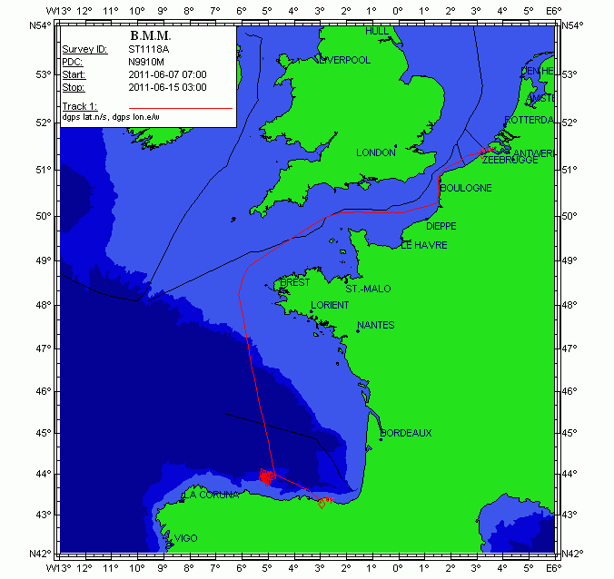
This cruise aims to investigate the seismic stratigraphy and palaeoceanographic evolution of the Le Danois contourite depositional system (Van Rooij et al., 2010), at several locations in the Le Danois "intraslope basin". Previous research (R/V Belgica in 2004, among others) has highlighted a significant correlation with the Cadiz CDS, suggesting a nearly simultaneous control by the Mediterranean Outflow Water since the Early Pliocene. As such, the Le Danois CDS is the only location in the Bay of Biscay where high-resolution climate change (e.g. bottom currents) may be recorded in a continuous way. It will assist in better constrain the role of the MOW in the thermohaline circulation system. Therefore, this large-scale sediment body is an ideal target for (a) investigating the MOW palaeoceanography within the NE Atlantic basin and (b) a palaeoclimatologic reconstruction of the Cantabrian margin. The main objective of this campaign is to acquire additional geophysical data which will give more insight in the construction and 3D evolution of this sedimentary deposit. This campaign will be executed in close cooperation with the Proyecto Coordinado CONTOURIBER (CTM 2008-06399-C04/MAR), with invited researchers from Spanish research institutes. More specifically, R/V Belgica ST1118a aims to perform: 1.High-resolution single channel sparker seismic profiling: investigation of the stratigraphic framework and the sedimentary environment in the western part of the intraslope basin between the Vizco High (west), the Lastras canyon system (east), Le Danois bank (north) and the Asturias slope (south). This will mainly focus on the lateral and temporal evolution of Le Danois drift and the Gijon drift and their interaction. The location of these profiles is determined based on industrial multichannel airgun profiles, in order to compare seismic methods with different penetration depths and seismic resolutions. We are very grateful to TGS-NOPEC for allowing us to use a large unpublished data set of seismic records from the Cantabrian Sea. 2.Hydrography: at specific sites in the intraslope basin, CTD casts will aim to better map the presence and behavior of the Mediterranean Outflow Water within the main elements of the Gijon and Le Danois drifts. The newly acquired Seapoint turbidity sensor will be able to indicate regions of active sediment transport within the Le Danois CDS. Multibeam bathymetry with the Belgica EM1002 will be only be used as a backup in case of spare time or failure of the other methods. The proponents are aware of the Marine Protected Area status of the Le Danois Bank, and will be vigilant to respect the guidelines of conducting scientific research. In order to ensure vigilance with respect to marine mammals, a team of whale watchers of MUMM, ULg (Belgium), CRMM (France) and OCEAMM (France) will be participating. This part of the campaign is a cooperation between the RCMG (UGent), the University of Vigo, the Geological Survey of Spain (IGME), the Spanish Oceanographic Institute (IEO), the Spanish Institute of Marine Sciences (CMIMA-CSIC) and the University of Cádiz.