Catálogo de datos del IEO
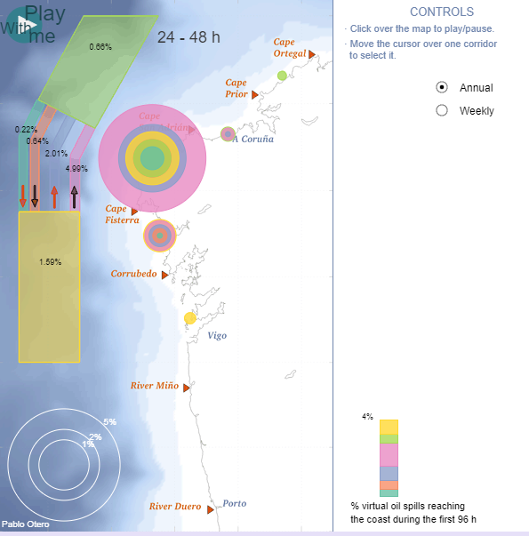
Visor: Impacto costero de vertidos en el corredor marítimo de Fisterra
Esta herramienta visualiza la exposición costera de la Eurorregión Galicia - Norte de Portugal a los potenciales vertidos de hidrocarburos que pudieran venir del dispositivo de separación de tráfico de Fisterra. Estos corredores son atravesados cada año por cerca de 40,000 buques; más del 30% de ellos transporta sustancias peligrosas.
Estos resultados corresponden a 2012, obtenidos mediante la ejecución de 8,686 simulaciones lagrangianas, cada una de las cuales contó con 2,345 partículas virtuales que fueron arrojadas sobre el corredor y seguidas durante las siguientes 96 horas. Las partículas fueron desplazadas por corrientes superficiales marinas obtenidas de un modelo oceánico realista de alta resolución y también por la acción del viento.
Se muestran además de los cuatro corredores que integran el dispositivo, las zonas de aproximación. El número que aparece sobre cada corredor es la probabilidad de que una partícula alcance la costa durante el primer, segundo, tercer o cuarto día tras el vertido. Los círculos representan la probabilidad de que alcance un determinado segmento de la costa. Es posible filtrar los datos colocando el puntero del ratón sobre un determinado corredor, facilitando la visualización.
|
|
. Visor: Impacto costero de vertidos en el corredor marítimo de Fisterra. http://datos.ieo.es/geonetwork/srv/api/records/5319d4d2-f894-4c9f-8f03-bb6d49e82396 |
Simple
- Fecha ( Creación )
- 2013-06-01
Autor
- Propósito
- Visualizar el impacto de posibles vertidos procedentes del corredor marítimo de Fisterra
- Crédito
- Instituto Español de Oceanografía
- Estado
- Terminado
Distribuidor
- Horas de servicio
- De 8 a 15 h.
- Instrucciones del Contacto
- Contactar por correo electrónico o por teléfono con el departamento de datos.
- ISO 3166 códigos de países ISO 3166 códigos de países ISO 3166 country codes ( Lugar )
-
- ESPAÑA
- theme.unescothes.rdf theme.unescothes.rdf ( Tema )
-
- Visor
- Aplicación web interactiva
- Datos oceanográficos
- Palabras clave
-
- temperatura
- SST
- Limitación de uso
- El IEO no se hace responsable del uso y/o interpretación realizada de la información, servicios, productos y/o datos suministrados. El IEO no garantiza la continuidad en la puesta a disposición de esta información, ni en contenido ni en forma, ni asume responsabilidades por cualquier error u omisión contenido en ella. El IEO se reserva el derecho a modificar, añadir o eliminar la información contenida en sus servidores.
- Restricciones de Acceso
- Licencia
- Otras limitaciones
-
Está permitida la combinación, transformación y creación de nuevo material a partir del original. Asimismo, está permitida la copia y redistribución, en cualquier medio y/o formato, siempre que se cumplan los siguientes requisitos:
i. Se incluya el reconocimiento al “Instituto Español de Oceanografía”(IEO), así como a otros organismos involucrados en la toma de datos cuando así lo indiquen los metadatos correspondientes.
ii. Se incluya los derechos de propiedad intelectual, condiciones de licencia y descarga de responsabilidades aquí presentes.
iii. Se incluya un enlace a la fuente de datos original o DOI (digital object identifier) en caso de su existencia.
iv. Se mantenga el logotipo de IEO en todos aquellos productos que lo lleven integrado.
v. Se informe al IEO a través de la cuenta de correo cedo@md.ieo.es.
vi. El material adaptado se comparta bajo las mismas condiciones de esta licencia.
Queda prohibido el uso con fines comerciales.
Para el resto de condiciones es aplicable la licencia pública Creative Commons Atribución-NoComercial-CompartirIgual 4.0 Internacional (CC BY-NC-SA 4.0) https://creativecommons.org/licenses/by-nc-sa/4.0/
- Tipo de representación espacial
- Vector
- Idioma del metadato
- Spanish; Castilian
- Codificación
- UTF8
- Categoría temática
-
- Océanos
))
- Identificador del Sistema de Referencia
- http://www.opengis.net/def/crs/EPSG/0/3041
- Tipo de objeto geométrico
- Punto
- Formato de la distribución
-
- ( )
Distribuidor
- Recurso en línea
- Impacto costero
- Jerarquía
- Conjunto de datos
Conformidad del Resultado
- Fecha ( Publicación )
- 2010-12-08
Identificador
- Explicación
- Consultar el reglamento mencionado.
- Aprobado
- false
- Declaración
- Otero, P. & Ruiz-Villarreal, Manuel & Allen-Perkins, Silvia & Vila, Begoña & Cabanas, Jose. (2014). Coastal exposure to oil spill impacts from the Finisterre Traffic Separation Scheme. Marine Pollution Bulletin. 85. 10.1016/j.marpolbul.2014.06.020.
Etapa del proceso
gmd:MD_Metadata
- Identificador del fichero
- 5319d4d2-f894-4c9f-8f03-bb6d49e82396 XML
- Idioma del metadato
- Spanish; Castilian
- Codificación
- UTF8
- Jerarquía
- Conjunto de datos
- Fecha
- 2021-03-24T11:14:04
- Nombre estándar del metadato
- NEM: ISO 19115:2003 + Reglamento (CE) Nº 1205/2008 de Inspire
- Versión estándar del metadato
- 1.2
Punto de Contacto
- Horas de servicio
- De 8 a 15 h.
- Instrucciones del Contacto
- Contactar por correo electrónico o por teléfono