Keyword
ship
18 record(s)
Type of resources
Categories
Topics
INSPIRE themes
Keywords
Contact for the resource
Provided by
Years
Formats
Status
-
cartografia de praderas submarinas con sonar de barrido lateral (proj PASCA1411)
-
Cr. First field campaign.
-

Recogida de datos geofisicos en la plataforma continental hasta los 30m , en la zona de Granada
-

Recogida de datos geofisicos en la plataforma continental hasta los 30m , zona de Almeria
-

Recogida de datos geofisicos en la plataforma continental hasta los 30m , adyacentes a la zona de Malaga
-

Recogida de datos geofisicos en la plataforma continental hasta los 30m , adyacentes a la zona de Gerona
-

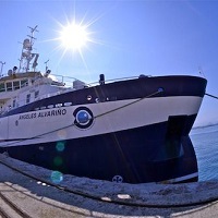
The campaign targets under TASIFE 0414, to carry on board the research vessel Angeles Alvariño, are the set up and maintenance of equipment deep underwater photography TASIFE 2013. Specific objectives focus on the investigation of benthic Banks areas of 'Reserva Marina de La Palma' and 'ZEC Franja Marina Teno-Rasca (Tenerife)' by direct and visual methods. Specifically: · Extensive visual videogrammetry HD with sled towed "NEXUS". · Recognition with multibeam bathymetric probe.
-

1. To test the sledge TST- HORUS and the methodology based on the identification and quantification of Nephrops burrows in order to estimate the Nephrops abundance using underwater images. 2. To obtain estimates of Nephrops borrows density 3. To obtain estimates of macro benthos density 4. To collect ancillary information on the occurence of trawl marks on sea bed 5. To collect sediment samples 6. To collect biological data on infauna 7. To obtain oceanographic data using a sledge mounted CTD
-

The goals of this survey are framed within the educational activity of the Faculty of Marine Sciences ULPGC to give the possibility of a complete oceanographic study (Physical , Chemical , Biological and Geological Survey ) in the south of Gran Canaria students of Degree, Bachelor and Master , the convergence zone between the area and the trail of the island and the presence of permanent rotation south of it. Thus this survey will contribute to a comprehensive training for students in oceanographic study of an oceanic region may Determine the structure of water bodies, the effects of convergence and divergence to the passage of the Canary Current across the channels between islands, mass transport , and nutrients. Determine the distribution of chemical species , including oxygen and carbon dioxide system and quantify the transport of CO2 in the atmosphere-ocean study area , the effect of micro and mesoscale phenomena in their distribution. To characterize the effect of the wake , turns and other mesoscale structures in the distribution of species of phytoplankton and zooplankton.
-

The campaign targets under INFUECO 1113, to carry on board the research vessel Angeles Alvariño, are the identification and mapping of habitats and characterization of biogenic benthic and demersal species. Specific objectives focus on the investigation of benthic Banks areas of 'Amanay' and 'El Banquete' by direct and visual methods. Specifically: · Extensive visual videogrammetry HD with sled towed "NEXUS". · Recognition with multibeam bathymetric probe.
 Catálogo de datos del IEO