 Catálogo de datos del IEO
Keyword
Optical backscatter
9 record(s)
Type of resources
Categories
Topics
INSPIRE themes
Keywords
Contact for the resource
Provided by
Years
Formats
Status
-
The northern "Contourite Depositional System" located within the Gulf of Cadiz is well studied and was drilled last year during IODP expedition 339. We aim to acquire 3 additional seismic lines over these drill sites towards the shallow shelf for sequence stratigraphic studies and acquire a connection profile to the southern part of the Gulf, along the Moroccan margin. The research along the Moroccan margin builds upon previous investigations (R/V Belgica 2002, 2005, 2008) and will focus on smaller current-related deposits in order to fully understand the hydro- and sediment dynamic picture of this area during the past 2.4 Ma. This will allow to better assess the evolution of cold-water coral ecosystems. This will be achieved by gathering additional seismic lines and perform hydrographic measurements. In the second half of June, several cores will be gathered from the southern part of the Gulf of Cadiz with the R/V Marion Dufresne. In order to visualize the subsurface of these core sites, 6 seismic profiles will be gathered, connecting these core sites.
-

The NUREIEV2 cruise targets the main objective of testing the hypothesis that sea storms are the main trigger for the transfer of matter and energy, including pollutants and litter, from the coastal to the deep ocean in the SE of Spain (36º20’N to 37º36’N and 2º40’W to 0º40’W). A dedicated strategy was performed during the NUREIEV2 cruise to achieve the objective including: 1) the collection of sediment cores (multicores) in the vicinity of the mine tailings deposit near the Portman Bay 2) the recovery and redeployment of mooring lines with automated sediment traps and currentmeters to monitor particle fluxes (including pollutants released from the mine tailings deposit) and near bottom oceanographic parameters (current speed and directions, temperature, transmissivity), 3) the profiling of the water column (by means of a CTD) to study physico-chemical characteristics of the water column, 4) the collection of floating debris including microplastics from surface waters 5) and the high resolution swath mapping and TOPAS profiling to investigate seafloor features.
-
The main target of the NUREIEVA-MAR-1 campaign is twofold. On the one hand, it aims to establish the geometry and the three-dimensional internal structure of the deposit of mineral discharges submerged in front of the Bay of Portmán and, on the other hand, it intends to verify the data obtained by obtaining witnesses from the deposit. During the campaign, a high resolution multibeam bathymetric cartography and a high density mesh of TOPAS PS18 parametric probe profiles will be carried out, and sediment tokens will be obtained by gravity or piston core grabs of the longest length possible, as well as by means of multicorer, box corer and dredge Van Veen for the upper part of the deposit. In addition, the discharge of dissolved metals from the deposit emerged at sea will be quantified using CTD profiles and sampling with hydrographic bottles. Floating microplastics will also be sampled.
-
The leg 1 of the NUREIEV 3 oceanographic cruise took place from 22 to 30 April 2016. The area of work has located on the continental margin of the SE of Iberian Peninsula, off the coast of Murcia and Almeria, with reference coordinates from 36º20'N to 37º36'N and 2º40'W to 0º40'W. The tasks performed consisted of: • Bathymetric mapping with multibeam echosounder for seabed mapping, from inner shelf to upper slope (50 to 1500 m depth). • Geophysical works with TOPAS, very high resolution seismic profiles, to characterize the sedimentary cover of the study area. • Recovery of 5 mooring lines, instrumented for the continuous monitoring of the hydrological (water masses) and sediment (particle fluxes) dynamics from the last cruise in September 2015. Each mooring line is composed by one current meter for measuring temperature, turbidity, velocity and direction of currents and one sediment trap for sampling sinking particles. In addition, each mooring is equipped with an acoustic release for recovery and with suitable buoyancy. Monitoring with instrumented mooring lines has covered an annual cycle, in two phases of 6 months each one. • CTD profiling and water sampling. Profiles have been made in each of the submarine canyons monitored for measuring physical and chemical variables of water column (temperature, salinity, turbidity, oxygen concentration and chlorophyll) and calibration of instruments of mooring lines. • Performing surface sampling of floating microplastics by neuston net. • Sampling of surface sediments by multicorer.
-

The main objetive of PLOCAN1304 cruise is twofold. On the one hand implement PLOCAN testing bank area, located in NE coast of Gran Canaria island, and on the other hand, doing seasonal sampling of ESTOC (Estacion de Series Temporales Oceánias de Canarias), which represents PLOCAN node oceanic observatory, located 60 nautical miles north of Gran Canaria island.
-
The main objetive of PLOCAN1310 cruise is twofold. On the one hand implement PLOCAN testing bank area, located in NE coast of Gran Canaria island, and on the other hand, doing seasonal sampling of ESTOC (Estacion de Series Temporales Oceánias de Canarias), which represents PLOCAN node oceanic observatory, located 60 nautical miles north of Gran Canaria island. Hydrological and Geophisical sampling at NER300 area.
-
The EU funded MIDAS RTD project (7th FP, gran agreement 603418) overarching objective is to determine the impact of deep-sea mining on deep marine ecosystems. To investigate the behaviour and the effects of heavy metal rich resuspended sediment plumes over benthic organisms and ecosystems, the University of Barcelona coordinates a plume generation and monitoring experiment in the bay of Portman, SE of Spain, where millions of tones of metal rich mine tails from onshore mines were dumped from 1957 to 1990. Prior to the seafloor disturbance experiment to generate the plumes, a careful mapping of the study area, and in particular of the area covered by the mine tails deposit was carried out. Two vessels are used for the disturbance experiment. The first vessel generates the plumes by bottom trawling, while the second one monitors the plume evolution through time with a variety of sensors, including acoustics. Moorings with sediment traps, current-meters, mussel ropes and baited traps are deployed in and around the seafloor area disturbed by the trawler.
-
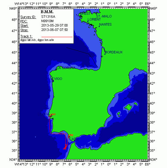
The cruise RadProf201209 is part of the timeseries program from the Spanish Institute of Oceanography (IEO) following international strategies for ocean climate monitoring (CLIVAR, GOOS etc). It covers a hydrographical section westwards of Cape Finisterre in Northwest Spain along the 43ºN latitude, extending c.a. 250 nm into the western Iberia basin. The sampling includes hydrography, current velocity fields and water samples collection for biogeopchemical analysis. It is planned the deployment of a mooring line at 43ºN; 11ºW, at a site where current measurements timeseries exist. RadProf201209 adds specific sampling of biogeochemical properties, organic matter and plankton in alliance with the research project BIOPROF.
-
The NUREIEV1 cruise targets the main objective of testing the hypothesis that sea storms are the main trigger for the transfer of matter and energy, including pollutants and litter, from the coastal to the deep ocean in the SE of Spain (36º20’N to 37º36’N and 2º40’W to 0º40’W). A dedicated strategy was performed during the NUREIEV1 cruise to achieve the objective including: 1) the collection of sediment cores (multicores and gravity cores) in the vicinity of the mine tailings deposit near the Portman Bay 2) the deployment of mooring lines with automated sediment traps and currentmeters to monitor particle fluxes (including pollutants released from the mine tailings deposit) and near bottom oceanographic parameters (current speed and directions, temperature, transmissivity), 3) the profiling of the water column (either from the ship by means of a CTD and from a little boat in the shallower stations) to study physico-chemical characteristics of the water column including dissolved trace elements and radiosotopes 4) the collection of floating debris including microplastics from surface waters 5) and the high resolution swath mapping and TOPAS profiling to investigate seafloor features.