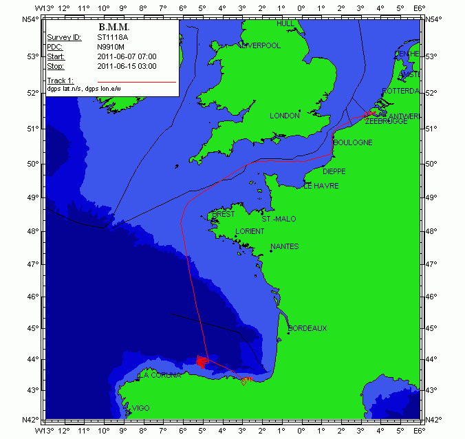
Campaña: ST1118a
This cruise aims to investigate the seismic stratigraphy and palaeoceanographic evolution of the Le Danois contourite depositional system (Van Rooij et al., 2010), at several locations in the Le Danois "intraslope basin". Previous research (R/V Belgica in 2004, among others) has highlighted a significant correlation with the Cadiz CDS, suggesting a nearly simultaneous control by the Mediterranean Outflow Water since the Early Pliocene. As such, the Le Danois CDS is the only location in the Bay of Biscay where high-resolution climate change (e.g. bottom currents) may be recorded in a continuous way. It will assist in better constrain the role of the MOW in the thermohaline circulation system.
Therefore, this large-scale sediment body is an ideal target for (a) investigating the MOW palaeoceanography within the NE Atlantic basin and (b) a palaeoclimatologic reconstruction of the Cantabrian margin. The main objective of this campaign is to acquire additional geophysical data which will give more insight in the construction and 3D evolution of this sedimentary deposit. This campaign will be executed in close cooperation with the Proyecto Coordinado CONTOURIBER (CTM 2008-06399-C04/MAR), with invited researchers from Spanish research institutes.
More specifically, R/V Belgica ST1118a aims to perform:
1.High-resolution single channel sparker seismic profiling: investigation of the stratigraphic framework and the sedimentary environment in the western part of the intraslope basin between the Vizco High (west), the Lastras canyon system (east), Le Danois bank (north) and the Asturias slope (south). This will mainly focus on the lateral and temporal evolution of Le Danois drift and the Gijon drift and their interaction. The location of these profiles is determined based on industrial multichannel airgun profiles, in order to compare seismic methods with different penetration depths and seismic resolutions. We are very grateful to TGS-NOPEC for allowing us to use a large unpublished data set of seismic records from the Cantabrian Sea.
2.Hydrography: at specific sites in the intraslope basin, CTD casts will aim to better map the presence and behavior of the Mediterranean Outflow Water within the main elements of the Gijon and Le Danois drifts. The newly acquired Seapoint turbidity sensor will be able to indicate regions of active sediment transport within the Le Danois CDS.
Multibeam bathymetry with the Belgica EM1002 will be only be used as a backup in case of spare time or failure of the other methods.
The proponents are aware of the Marine Protected Area status of the Le Danois Bank, and will be vigilant to respect the guidelines of conducting scientific research. In order to ensure vigilance with respect to marine mammals, a team of whale watchers of MUMM, ULg (Belgium), CRMM (France) and OCEAMM (France) will be participating.
This part of the campaign is a cooperation between the RCMG (UGent), the University of Vigo, the Geological Survey of Spain (IGME), the Spanish Oceanographic Institute (IEO), the Spanish Institute of Marine Sciences (CMIMA-CSIC) and the University of Cádiz.
|
|
. Campaña: ST1118a. http://datos.ieo.es/geonetwork/srv/api/records/urn:SDN:CSR:LOCAL:SI29201106070 |
Simple
- Título alternativo
- Referencia IEO: BSH20113212
- Fecha ( Creación )
- 2011-06-15
- Identificador
- urn:SDN:CSR:LOCAL:BSH20113212
Orígen
- Estado
- Terminado
Punto de Contacto
- GEMET - INSPIRE themes, version 1.0 ( Tema )
-
- Oceanographic geographical features
- Ten-degree Marsden Squares ( marsden_square )
-
- 145
- SeaDataNet Ports Gazetteer ( departure_place )
-
- Zeebrugge
- SeaDataNet Ports Gazetteer ( arrival_place )
-
- Bilbao
- International Standards Organisation countries ( departure_country )
-
- Belgium
- International Standards Organisation countries ( arrival_country )
-
- Spain
- ICES Platform Codes ( platform )
-
- Belgica
- SeaVoX Platform Categories ( platform_class )
-
- research vessel
- SeaVoX salt and fresh water body gazetteer ( Lugar )
-
- Bay of Biscay
- BODC Parameter Discovery Vocabulary ( parameter )
-
- Cetacean abundance
- Turbulence in the water column
- Bird counts
- Seismic reflection
- Temperature of the water column
- Density of the water column
- Cetacean behaviour
- Bird behaviour
- Salinity of the water column
- Suspended particulate material grain size parameters
- SeaDataNet device categories ( instrument )
-
- Sparker
- centrifuges
- CTD
- >2000 Hz top-bandwidth single-channel seismic reflection systems
- Limitación de uso
- Not applicable
- Restricciones de Acceso
- Restricted
- Otras limitaciones
- Idioma del metadato
- Spanish; Castilian
- Codificación
- utf8 UTF8
- Categoría temática
-
- Océanos
))
- Fecha de inicio
- 2011-06-07T00:00:00Z
- Fecha de finalización
- 2011-06-15T00:00:00Z
- Identificador del Sistema de Referencia
-
World Geodetic System 84
- Título alternativo
- L10
- Fecha ( Revisión )
- 2011-03-03
- Edición
- 3
- Identificador
- https://www.seadatanet.org/urnurl/SDN:L10
- Formato de la distribución
-
- XML (1 )
- Recurso en línea
-
Base de datos internacional con información de campañas desde 1873 hasta la actualidad. La presente campaña la podrás encontrar como ST1118a.
SeaDataNet - CRS inventory
- Recurso en línea
-
Descubre si hay datos de esta campaña disponibles, utilizando para ello la etiqueta ST1118a en el buscador de datos de SeaDataNet.
SeaDataNet - CDI inventory
- Jerarquía
- Campaña/Survey Campañas
Conformidad del Resultado
- Fecha ( Publicación )
- 2010-12-08
- Explicación
- See the referenced specification
- Aprobado
- true
Conformidad del Resultado
- Fecha ( Publicación )
- 2010-12-08
- Explicación
- See the referenced specification
- Aprobado
- true
- Declaración
- El Centro de datos aplica controles de calidad estandarizados a todos los datos de los que es responsable. Contacta con el Centro de datos para más información.
gmd:MD_Metadata
- Identificador del fichero
- urn:SDN:CSR:LOCAL:SI29201106070 XML
- Idioma del metadato
- Spanish; Castilian
- Codificación
- utf8 UTF8
- Jerarquía
- Campaña/Survey Campañas
- Nombre del nivel de jerarquía
- Cruise Summary record
- Fecha
- 2021-11-28
- Nombre estándar del metadato
- ISO 19115/SeaDataNet profile
- Versión estándar del metadato
- 1.0
 Catálogo de datos del IEO

