Catálogo de datos del IEO
Campaña: PRISME
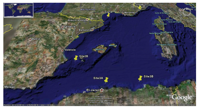
<p>The PRISME cruise objectives were to: - quantify the risk of earthquake-induced sedimentary liquefaction (for areas studied on the Algerian margin and slope off Nice, France); - quantify the risk of instability and failure due to loss of resistance in sensitive clay (slope off Nice); - quantify the risk of slope breaks and erosion caused by bottom currents (canyon heads - gulf of Lion); - identify the triggering factors for slides seen off Ibiza; - and begin to identify the turbidity related to seismic activity along the Algerian margin. This falls under the ANR-Isis an dGDR Marges projects. The cruise took place on 5 sites: Site 1A - Gulf of Lion - North: N 42° 50.00' South: N 42° 40.00' West: E 003° 35.00' East: E 004° 0.00' / Site 2B - Ibiza channel - North: N 38° 39.00' South: N 38° 37.50' West: E 000° 47.00' East: E 000° 51.00' / Site 3A - Alger - North: N 37° 30.00' South: N 36° 40.00' West: E 002° 00.00' East: E 004° 00.00' / Site 3B - Djijel North: N 37° 30.00' South: N 37° 00.00' West: E 005° 00.00' East: E 004° 00.00' / Site 4A - Djijel North: N 43° 40.00' South: N 43° 38.00' West: E 007° 12.00' East: E 007° 15.00'.</p>
|
|
. Campaña: PRISME. http://datos.ieo.es/geonetwork/srv/api/records/urn:SDN:CSR:LOCAL:SI29200710070 |
INSPIRE
Identificación
- Identificador del fichero
- urn:SDN:CSR:LOCAL:SI29200710070 XML
- Jerarquía
- Campaña/Survey Campañas
Recurso en línea
- resource_protocol
- WWW:LINK-1.0-http--related
- resource_protocol
- WWW:LINK-1.0-http--related
Identificador del recurso
- code
- urn:SDN:CSR:LOCAL:7010090
- Idioma del metadato
- Spanish; Castilian
Codificacióin
- Formato
- XML
- Versión
- 1
Proyección
- code
- World Geodetic System 84
Classification of data and services
- Categoría temática
-
- Océanos
Classification of data and services
Coupled resource
Coupled resource
Classification of data and services
Coupled resource
Coupled resource
Palabras clave
- GEMET - INSPIRE themes, version 1.0 ( Tema )
-
- Oceanographic geographical features
- Ten-degree Marsden Squares ( marsden_square )
-
- 144
- 180
- 109
- SeaDataNet Ports Gazetteer ( departure_place )
-
- La Seyne-sur-Mer
- SeaDataNet Ports Gazetteer ( arrival_place )
-
- La Seyne-sur-Mer
- International Standards Organisation countries ( departure_country )
-
- France
- International Standards Organisation countries ( arrival_country )
-
- France
- ICES Platform Codes ( platform )
-
- L'Atalante
- SeaVoX Platform Categories ( platform_class )
-
- research vessel
- SeaVoX salt and fresh water body gazetteer ( Lugar )
-
- Mediterranean Sea, Western Basin
- SeaDataNet device categories ( instrument )
-
- bathythermographs
- single-beam echosounders
- multi-beam echosounders
- meteorological packages
- gravimeters
- current profilers
- sidescan sonars
- single-channel seismic reflection systems
- European Directory for Marine Environmental Research Projects ( project )
-
- MARGES - MARGES
Other keywords
Cobertura geográfica
N
S
E
W
))
N
S
E
W
))
N
S
E
W
))
N
S
E
W
))
Temporal reference
Extensión tempora
- Inicio
- 2007-10-07T00:00:00Z
- Fin
- 2007-11-07T00:00:00Z
Extensión tempora
- Fecha ( Creación )
- 2007-11-07
Quality and validity
- Linaje
- El Centro de datos aplica controles de calidad estandarizados a todos los datos de los que es responsable. Contacta con el Centro de datos para más información.
Conformidad
Conformidad
Conformidad
Conformidad
Conformidad
Conformidad
- Explicación
- See the referenced specification
- Explicación
- See the referenced specification
Restrictions on access and use
- Limitación de uso
- Not applicable
- Restricciones de Acceso
Restrictions on access and use
Responsible organization (s)
Contacto para el recurso
- Nombre de la organización
- Ifremer, Marine Geosciences
Responsible organization (s)
Contacto para el recurso
- Nombre de la organización
- Ifremer, Marine Geosciences
Metadata information
Contacto para el metadato
- Nombre de la organización
- Instituto Español de Oceanografía
- N/A
- Fecha
- 2021-11-28
- Idioma del metadato
- Spanish; Castilian
- Codificación
- utf8 UTF8