Catálogo de datos del IEO
Mareógrafo de Palma de Mallorca (PSMSL ID: 1892) - Datos de nivel del mar
|
|
. Mareógrafo de Palma de Mallorca (PSMSL ID: 1892) - Datos de nivel del mar. http://datos.ieo.es/geonetwork/srv/api/records/cd43588f-f14d-40d0-a982-20deae9fbe0c |
INSPIRE
Identificación
- Identificador del fichero
- cd43588f-f14d-40d0-a982-20deae9fbe0c XML
- Jerarquía
- Conjunto de datos
Recurso en línea
- resource_protocol
- WWW:LINK-1.0-http--link
- resource_protocol
- WWW:LINK-1.0-http--link
- resource_protocol
- WWW:LINK-1.0-http--related
Identificador del recurso
- Idioma del metadato
- Spanish; Castilian
- Tipo de representación espacial
- Vector
Codificacióin
- Formato
- Text
- Versión
Proyección
Classification of data and services
- Categoría temática
-
- Océanos
Classification of data and services
Coupled resource
Coupled resource
Classification of data and services
Coupled resource
Coupled resource
Palabras clave
- GEMET - INSPIRE themes, version 1.0 GEMET - INSPIRE themes, version 1.0 ( Tema )
-
- Rasgos geográficos oceanográficos
- Instalaciones de observación del medio ambiente
- European Territorial Units European Territorial Units European Territorial Units ( Lugar )
-
- ESPAÑA
- Palma de Mallorca
- ISO 3166 códigos de países ISO 3166 códigos de países ISO 3166 country codes ( Lugar )
-
- ESPAÑA
- Temática UNESCO Temática UNESCO UNESCO Themes ( Tema )
-
- Oceanografía física
- Oceanografía
- Nivel del mar
- Datos oceanográficos
- Equipo oceanográfico
- Medición oceanográfica
- Mar Mediterráneo
- Marea
- Mar
Other keywords
Cobertura geográfica
))
Temporal reference
Extensión tempora
- Inicio
- 1997-01-01T11:45:30
Extensión tempora
- Fecha ( Creación )
- 1997-01-01
Quality and validity
- Linaje
-
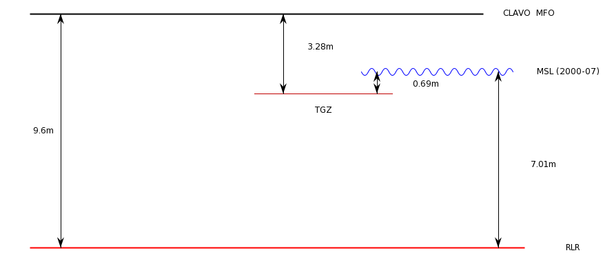
El mareógrafo se encuentra en el puerto de Mallorca (39.552381º N, 2.638912º E). Datum information: Datos referidos a: Tide Gauge Zero (TGZ).
Añadidos 6.320m a todos los datos para referirse a RLR
RLR está 9.6m por debajo de la marca CLAVO MFO
TGBM: Clavo - Mfo
Aux1: Clavo – City council: 1.085 m por debajo de TGBM
TGZ: 3.280 m por debajo de TGBM
TGZ:: 2.195 m por debajo de Aux1
TGZ: Cero hidrográfico (necesita ser recalculado)
El control de calidad se aplica a la fecha, hora, spikes, residuos y comparación con estaciones cercanas.
Conformidad
Conformidad
Conformidad
Conformidad
Conformidad
Conformidad
- Explicación
- Consultar el reglamento mencionado.
Restrictions on access and use
- Restricciones de Acceso
-
Se permite cualquier uso educativo o con fines de investigación no comercial, siempre que se mencione al Instituto Español de Oceanografía.
Atribución/Reconocimiento-NoComercial-CompartirIgual 4.0 Internacional
https://creativecommons.org/licenses/by-nc-sa/4.0/legalcode.es
Restrictions on access and use
Responsible organization (s)
Contacto para el recurso
- Nombre de la organización
- Instituto Español de Oceanografía
- cedo@ieo.es
Responsible organization (s)
Contacto para el recurso
- Nombre de la organización
- Instituto Español de Oceanografía
- cedo@ieo.es
Metadata information
Contacto para el metadato
- Nombre de la organización
- Instituto Español de Oceanografía
- cedo@ieo.es
- Fecha
- 2021-03-24T10:16:21
- Idioma del metadato
- Spanish; Castilian
- Codificación
- UTF8