 Catálogo de datos del IEO
Mareógrafo de Puerto de la Luz (PSMSL ID: 565) - Datos de nivel del mar
|
|
. Mareógrafo de Puerto de la Luz (PSMSL ID: 565) - Datos de nivel del mar. http://datos.ieo.es/geonetwork/srv/api/records/948690fb-6294-4796-beaf-71a5cd453b05 |
Simple
- Título alternativo
- Mareógrafo Puerto de la Luz
- Fecha ( Creación )
- 1949-01-01
- Propósito
- Medir la variación temporal del nivel del mar
- Crédito
- Instituto Español de Oceanografía
- Estado
- En proceso
Punto de Contacto
- Horas de servicio
- De 8 a 15 h.
- Instrucciones del Contacto
- Contactar por correo electrónico o por teléfono con el departamento de datos.
- Mantenimiento y frecuencia de actualización
- Continuamente
- Nota de mantenimient
- continual
- European Territorial Units European Territorial Units European Territorial Units ( Lugar )
-
- ESPAÑA
- Las Palmas de Gran Canaria
- GEMET - INSPIRE themes, version 1.0 GEMET - INSPIRE themes, version 1.0 ( Tema )
-
- Environmental monitoring facilities
- Oceanographic geographical features
- ISO 3166 códigos de países ISO 3166 códigos de países ISO 3166 country codes ( Lugar )
-
- ESPAÑA
- Temática UNESCO Temática UNESCO UNESCO Themes ( Tema )
-
- Oceanografía física
- Oceanografía
- Nivel del mar
- Datos oceanográficos
- Equipo oceanográfico
- Medición oceanográfica
- Océano Atlántico
- Marea
- Mar
- Limitación de uso
- Restricciones de Acceso
- Licencia
- Otras limitaciones
-
Se permite cualquier uso educativo o con fines de investigación no comercial, siempre que se mencione al Instituto Español de Oceanografía.
Atribución/Reconocimiento-NoComercial-CompartirIgual 4.0 Internacional
https://creativecommons.org/licenses/by-nc-sa/4.0/legalcode.es
- Tipo de representación espacial
- Vector
- Idioma del metadato
- Spanish; Castilian
- Codificación
- UTF8
- Categoría temática
-
- Océanos
))
- Fecha de inicio
- 1949-01-01T11:45:30
- Identificador del Sistema de Referencia
- http://www.opengis.net/def/crs/EPSG/0/3041
- Tipo de objeto geométrico
- Punto
- Formato de la distribución
-
- Text ( )
Distribuidor
- Recurso en línea
- Datos en formato texto de los últimos 15 días (Radar)
- Recurso en línea
- Gráfico últimos datos (Radar)
- Recurso en línea
- Datos en formato texto de los últimos 15 días (Flotador)
- Recurso en línea
- Gráfico últimos datos (Flotador)
- Recurso en línea
-
PSMSL Data Explorer (ID 565)
Explora la red mundial de mareógrafos
- Recurso en línea
-
GLOSS UNESCO/IOC
Accede a los datos de esta estación a través de la web de Global Sea Level Observing System (GLOSS)
- Recurso en línea
-
Imágenes de los registros gráficos (mareogramas).
Scanned images from graph records in paper (mareograms).
Imágenes de los registros gráficos (mareogramas). Scanned images from graph records in paper (mareograms).
- Jerarquía
- Conjunto de datos
Conformidad del Resultado
- Fecha ( Publicación )
- 2010-12-08
Identificador
- Explicación
- Consultar el reglamento mencionado.
- Aprobado
- true
- Declaración
-
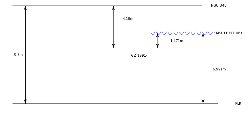
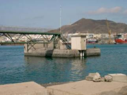
El mareógrafo de Puerto de la Luz (Las Palmas de Gran canaria) se encuentra en el dique de abrigo Reina Sofía. Lat : 28º 08’ N Lon : 15º 25’ W. Los datos de referencia de la estación son:
TGBM : NGU-340 Dentro del edificio que alberga la instrumentación
Aux1: SS2M Próximo al edificio que alberga la instrumentación
Aux2 : SS3M En el dique, frente al edificio que alberga la instrumentación
TGZ : 0.08 m sobre el cero hidrográfico
TGZ : 1.444 m por debajo del nivel medio del mar (local)
TGZ : 4.179 m por debajo de TGBM (NGU.340)
TGZ : 3.891 m por debajo de Aux1(SS2M)
TGZ : 4.164 m por debajo de Aux2 (SS3M)
El control de calidad se ejerce sobre fecha, hora, spikes, residuos y comparación con estaciones cercanas.
Los datos de la estación GLOSS se actualizan diariamente en el sitio web COI-UNESCO: http://www.ioc-sealevelmonitoring.org/
Etapa del proceso
gmd:MD_Metadata
- Identificador del fichero
- 948690fb-6294-4796-beaf-71a5cd453b05 XML
- Idioma del metadato
- Spanish; Castilian
- Codificación
- UTF8
- Jerarquía
- Conjunto de datos
- Fecha
- 2021-03-24T10:14:13
- Nombre estándar del metadato
- NEM: ISO 19115:2003 + Reglamento (CE) Nº 1205/2008 de Inspire
- Versión estándar del metadato
- 1.2
Punto de Contacto
- Horas de servicio
- De 8 a 15 h.
- Instrucciones del Contacto
- Contactar por correo electrónico o por teléfono
