Catálogo de datos del IEO
Mareógrafo de Málaga (PSMSL ID: 496) - Datos de nivel del mar
|
|
. Mareógrafo de Málaga (PSMSL ID: 496) - Datos de nivel del mar. http://datos.ieo.es/geonetwork/srv/api/records/917e1f4b-7dba-4950-ad5c-af52387e9faf |
INSPIRE
Identificación
- Identificador del fichero
- 917e1f4b-7dba-4950-ad5c-af52387e9faf XML
- Jerarquía
- Conjunto de datos
Recurso en línea
- resource_protocol
- WWW:LINK-1.0-http--related
- resource_protocol
- WWW:DOWNLOAD-1.0-http--download
Identificador del recurso
- Idioma del metadato
- Spanish; Castilian
- Tipo de representación espacial
- Vector
Codificacióin
- Formato
- Versión
Proyección
Classification of data and services
- Categoría temática
-
- Océanos
Classification of data and services
Coupled resource
Coupled resource
Classification of data and services
Coupled resource
Coupled resource
Palabras clave
- GEMET - INSPIRE themes, version 1.0 GEMET - INSPIRE themes, version 1.0 ( Tema )
-
- Instalaciones de observación del medio ambiente
- Rasgos geográficos oceanográficos
- European Territorial Units European Territorial Units European Territorial Units ( Lugar )
-
- ESPAÑA
- Algeciras
- ISO 3166 códigos de países ISO 3166 códigos de países ISO 3166 country codes ( Lugar )
-
- ESPAÑA
- Temática UNESCO Temática UNESCO UNESCO Themes ( Tema )
-
- Oceanografía física
- Oceanografía
- Nivel del mar
- Datos oceanográficos
- Equipo oceanográfico
- Medición oceanográfica
- Mar Mediterráneo
- Marea
- Mar
Other keywords
Cobertura geográfica
))
Temporal reference
Extensión tempora
- Inicio
- 1943-01-01T11:45:30
Extensión tempora
- Fecha ( Creación )
- 1943-01-01
Quality and validity
- Linaje
-
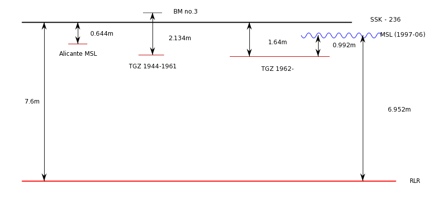
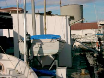
El mareógrafo se encuentra en el puerto de Málaga, con un hueco en la serie entre 1969 y 1961. Se indican a continuación los datos de referencia para la estación:
Lat : 36º 43’ N Lon : 04º 25’ W
TGBM SSK 236
TGZ : 1.640 m por debajo de TGBM
Cero hidrográfico: 1.176 m por debajo de TGBM (SSK-236)
Datos referidos a Tide Gauge Zero (TGZ).
El control de calidad se aplica a la fecha, hora, spikes, residuos y comparación con estaciones cercanas.
Conformidad
Conformidad
Conformidad
Conformidad
Conformidad
Conformidad
- Explicación
- Consultar el reglamento mencionado.
Restrictions on access and use
- Restricciones de Acceso
-
Se permite cualquier uso educativo o con fines de investigación no comercial, siempre que se mencione al Instituto Español de Oceanografía.
Atribución/Reconocimiento-NoComercial-CompartirIgual 4.0 Internacional
https://creativecommons.org/licenses/by-nc-sa/4.0/legalcode.es
Restrictions on access and use
Responsible organization (s)
Contacto para el recurso
- Nombre de la organización
- Instituto Español de Oceanografía
- cedo@ieo.es
Responsible organization (s)
Contacto para el recurso
- Nombre de la organización
- Instituto Español de Oceanografía
- cedo@ieo.es
Metadata information
Contacto para el metadato
- Nombre de la organización
- Instituto Español de Oceanografía
- cedo@ieo.es
- Fecha
- 2021-03-24T11:20:04
- Idioma del metadato
- Spanish; Castilian
- Codificación
- UTF8